Poster Print > Europe > United Kingdom > England > London > Art > Paintings
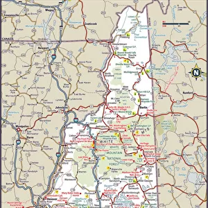
Poster Print : Antique map of New Hampshire USA 19th century 1819


![]()
Poster Prints from Fine Art Storehouse
Antique map of New Hampshire USA 19th century 1819
This is a copperplate engraving, a 19th century map of New Hampshire in the United States of America, with hand-coloured borders with Canada, Maine, Massachusetts and Vermont. Captions: 72 Longitude West from London 71. New Hampshire. 3 Longitude East from Philadelphia 4. The map is from Arrowsmith & Lewis, published by John Conrad & Co. and is from A New and Elegant General Atlas published in 1819. The map shows topography, towns, townships, counties and roads
Unleash your creativity and transform your space into a visual masterpiece!
Whiteway
Media ID 15387389
© Whiteway
Copper Engraving Isolated New Hampshire The Americas Image Created 19th Century
A3 (42 x 29.7cm) Poster Print
Step back in time with our exquisite Antique Map of New Hampshire print from the Media Storehouse collection at Fine Art Storehouse. This beautiful 19th century map, dating back to 1819, is a stunning copperplate engraving that showcases the historical geography of New Hampshire in remarkable detail. Delicately hand-colored borders gracefully frame the map, featuring Canada, Maine, Massachusetts, and Vermont. Add an air of timeless charm to any room with this captivating piece of historical art.
Premium quality poster prints are printed on luxurious semi-gloss satin 270 gsm paper. Our meticulously crafted poster prints offer an affordable option for decorating any space, making them ideal for living rooms, bedrooms, offices and beyond. To ensure your poster arrives in good condition, we roll and send them in strong mailing tubes.
Poster prints are budget friendly enlarged prints in standard poster paper sizes (A0, A1, A2, A3 etc). Whilst poster paper is sometimes thinner and less durable than our other paper types, they are still ok for framing and should last many years. Our Archival Quality Photo Prints and Fine Art Paper Prints are printed on higher quality paper and the choice of which largely depends on your budget.
Estimated Product Size is 30.6cm x 42.6cm (12" x 16.8")
These are individually made so all sizes are approximate
Artwork printed orientated as per the preview above, with portrait (vertical) orientation to match the source image.
FEATURES IN THESE COLLECTIONS
> Fine Art Storehouse
> Map
> Historical Maps
> Fine Art Storehouse
> Map
> USA Maps
> Fine Art Storehouse
> Photo Libraries
> The Illustrated London News (ILN)
> Arts
> Artists
> A
> John Arrowsmith
> Europe
> France
> Canton
> Maine
> Europe
> United Kingdom
> England
> Hampshire
> Canada
> Europe
> United Kingdom
> England
> Hampshire
> Related Images
> Europe
> United Kingdom
> England
> Hampshire
> West Town
> Europe
> United Kingdom
> England
> London
> Art
> Paintings
> Europe
> United Kingdom
> England
> London
> Related Images
> North America
> Canada
> Maps
> North America
> Canada
> Related Images
EDITORS COMMENTS
This print showcases an exquisite antique map of New Hampshire, USA, dating back to the 19th century. Created in 1819 through a meticulous copperplate engraving technique, this map is a true testament to the artistry and precision of its time. The borders are delicately hand-colored, highlighting the boundaries with Canada, Maine, Massachusetts, and Vermont. The detailed captions on the map reveal fascinating geographical information: longitude measurements from London and Philadelphia pinpointing specific locations within New Hampshire. This particular piece originates from Arrowsmith & Lewis and was published by John Conrad & Co. , featured in their renowned A New and Elegant General Atlas released in 1819. As we delve into this historical treasure trove of knowledge, we discover that it not only depicts topography but also towns, townships, counties, and roads prevalent during that era. It provides a glimpse into how life unfolded in early 19th-century New Hampshire. Preserved meticulously over centuries as an engraved image on paper with vibrant colors adorning its surface; this vertical print transports us back to a time when cartography was both science and art. Its isolation against a blank background allows us to focus solely on the intricate details presented by this copper engraving. A remarkable piece for collectors or enthusiasts alike; Whiteway's reproduction ensures that this slice of American history remains accessible for generations to come.
MADE IN AUSTRALIA
Safe Shipping with 30 Day Money Back Guarantee
FREE PERSONALISATION*
We are proud to offer a range of customisation features including Personalised Captions, Color Filters and Picture Zoom Tools
SECURE PAYMENTS
We happily accept a wide range of payment options so you can pay for the things you need in the way that is most convenient for you
* Options may vary by product and licensing agreement. Zoomed Pictures can be adjusted in the Cart.