Poster Print > Fine Art Storehouse > Map
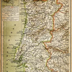
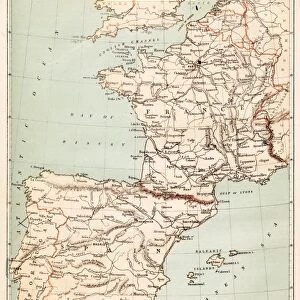
Poster Print : Spain France Portugal map 1867


![]()
Poster Prints from Fine Art Storehouse
Spain France Portugal map 1867
Mitchellas Modern Atlas - Published by E.H. Butler and Co - Philadelphia 1867
Unleash your creativity and transform your space into a visual masterpiece!
THEPALMER
Media ID 13609217
© This content is subject to copyright
A4 (29.7 x 21cm) Poster Print
Step back in time with our exquisite reproduction of the "Spain France Portugal map 1867" from THEPALMER's Mitchell's Modern Atlas. Published by E.H. Butler and Co in Philadelphia, this detailed and captivating map offers a glimpse into the historical geography of Europe during the 19th century. Bring a piece of history into your home or office with our high-quality poster print. Perfect for history enthusiasts, educators, or anyone who appreciates the beauty of vintage maps.
Premium quality poster prints are printed on luxurious semi-gloss satin 270 gsm paper. Our meticulously crafted poster prints offer an affordable option for decorating any space, making them ideal for living rooms, bedrooms, offices and beyond. To ensure your poster arrives in good condition, we roll and send them in strong mailing tubes.
Poster prints are budget friendly enlarged prints in standard poster paper sizes (A0, A1, A2, A3 etc). Whilst poster paper is sometimes thinner and less durable than our other paper types, they are still ok for framing and should last many years. Our Archival Quality Photo Prints and Fine Art Paper Prints are printed on higher quality paper and the choice of which largely depends on your budget.
Estimated Product Size is 21.6cm x 30.3cm (8.5" x 11.9")
These are individually made so all sizes are approximate
Artwork printed orientated as per the preview above, with portrait (vertical) orientation to match the source image.
FEATURES IN THESE COLLECTIONS
> Fine Art Storehouse
> Map
> Historical Maps
> Fine Art Storehouse
> Map
> USA Maps
EDITORS COMMENTS
This print showcases a remarkable piece of history - the Spain France Portugal map from 1867. Taken from Mitchellas Modern Atlas and published by E. H. Butler and Co in Philadelphia, this antique lithograph offers a glimpse into the world of cartography during that era. The intricate details etched onto the map are truly awe-inspiring. From the delicate engravings to the precise illustrations, every line tells a story of exploration and discovery. The vertical orientation adds an elegant touch to this vintage masterpiece. As we delve into its contents, we are transported back in time to a Europe where borders were different, yet interconnected. Spain, France, and Portugal take center stage on this old-world map while neighboring countries like Belgium also make their presence known. Beyond its aesthetic appeal lies an invaluable resource for understanding physical geography as it was understood over 150 years ago. This lithograph serves as a testament to human curiosity and our unending quest for knowledge about our planet. "The Palmer" whose name is attributed to this extraordinary artwork found at Fine Art Storehouse, has skillfully captured not only the essence of this historical artifact but also its significance in shaping our understanding of European geography. Whether displayed in homes or educational institutions, this print invites viewers to embark on a visual journey through time and space – reminding us all that even within art prints lie stories waiting to be explored.
MADE IN AUSTRALIA
Safe Shipping with 30 Day Money Back Guarantee
FREE PERSONALISATION*
We are proud to offer a range of customisation features including Personalised Captions, Color Filters and Picture Zoom Tools
SECURE PAYMENTS
We happily accept a wide range of payment options so you can pay for the things you need in the way that is most convenient for you
* Options may vary by product and licensing agreement. Zoomed Pictures can be adjusted in the Cart.