Poster Print > Africa > Cameroon > Maps
Poster Print : The Conquest of the Cameroons, First World War, 1914-1916, (c1920). Creator: Unknown
. Creator: Unknown")


![]()
Poster Prints from Heritage Images
The Conquest of the Cameroons, First World War, 1914-1916, (c1920). Creator: Unknown
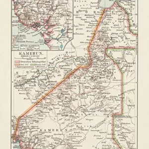
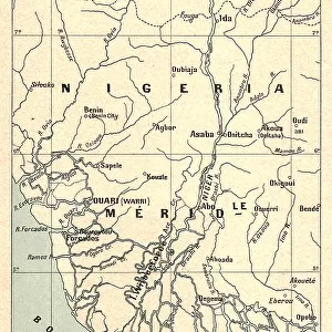
The Conquest of the Cameroons, First World War, 1914-1916, (c1920)....map showing approximately how the colony was cleared of the German troops, and the scene of the escape of their main force into Spanish Guinea. Also shown are: A, General [Charles Macpherson] Dobells main columns, with French columns under Colonel Mayer. B, French southern columns. C, Franco-Belgian columns from French Equatorial Africa and Belgian Congo. D, Franco- British columns under Brigadier-General [Frederick Hugh] Cunliffe. E, Northern column under Lieutenant-Colonel Brisset. German Cameroon was an African colony of the German Empire from 1884 to 1916. From " The Great World War: A History", Volume V, edited by Frank A Mumby. [The Gresham Publishing Company Ltd, London, c1920]
Heritage Images features heritage image collections
Media ID 19665945
© The Print Collector/Heritage Images
Belgian Congo Cameroon Colony Congo Frank A Frank A Mumby Frank Arthur Frank Arthur Mumby German Empire Gresham Publishing Co Ltd Gresham Publishing Company Imperialism Keystone Archives Mumby Mumby Frank A Mumby Frank Arthur Nigeria The Great World War A History Theatre Of War Cameroons
A4 (29.7 x 21cm) Poster Print
Step back in time with our vintage poster print from the Media Storehouse collection, featuring the historic Conquest of the Cameroons during the First World War, 1914-1916. This captivating, unknown creation from the early 1900s showcases a map illustrating the approximate progression of the Allied forces in clearing German troops from the colony. Add a touch of history and nostalgia to your space with this intriguing, one-of-a-kind piece.
Premium quality poster prints are printed on luxurious semi-gloss satin 270 gsm paper. Our meticulously crafted poster prints offer an affordable option for decorating any space, making them ideal for living rooms, bedrooms, offices and beyond. To ensure your poster arrives in good condition, we roll and send them in strong mailing tubes.
Poster prints are budget friendly enlarged prints in standard poster paper sizes (A0, A1, A2, A3 etc). Whilst poster paper is sometimes thinner and less durable than our other paper types, they are still ok for framing and should last many years. Our Archival Quality Photo Prints and Fine Art Paper Prints are printed on higher quality paper and the choice of which largely depends on your budget.
Estimated Product Size is 21.6cm x 30.3cm (8.5" x 11.9")
These are individually made so all sizes are approximate
Artwork printed orientated as per the preview above, with landscape (horizontal) or portrait (vertical) orientation to match the source image.
FEATURES IN THESE COLLECTIONS
> Africa
> Cameroon
> Related Images
> Africa
> Equatorial Guinea
> Maps
> Africa
> Equatorial Guinea
> Related Images
> Africa
> Guinea
> Related Images
> Africa
> Nigeria
> Related Images
> Africa
> Related Images
The Conquest of the Cameroons, First World War, 1914-1916
EDITORS COMMENTS
. This print showcases a detailed map depicting the remarkable events that unfolded during the conquest of German Cameroon in the First World War. Created around 1920 by an unknown artist, this historical piece offers a glimpse into a significant chapter in African colonial history. The map vividly illustrates how General Charles Macpherson Dobell's main columns, accompanied by French columns under Colonel Mayer (marked as A), played a crucial role in clearing the colony of German troops. Additionally, it highlights French southern columns (B), Franco-Belgian columns from French Equatorial Africa and Belgian Congo (C), Franco-British columns led by Brigadier-General Frederick Hugh Cunliffe (D), and Lieutenant-Colonel Brisset's Northern column (E). These combined forces strategically worked to reclaim control over this African territory. Notably depicted on this map is the escape route taken by the retreating German main force into Spanish Guinea. This visual representation provides valuable insight into both military tactics employed during warfare and geographical aspects of West Africa at that time. Taken from "The Great World War: A History" edited by Frank A Mumby, Volume V, this print serves as an educational resource for those interested in understanding the complexities of imperialism and colonialism during this era. It stands as a testament to human resilience and determination amidst one of history's most devastating conflicts – World War I.
MADE IN AUSTRALIA
Safe Shipping with 30 Day Money Back Guarantee
FREE PERSONALISATION*
We are proud to offer a range of customisation features including Personalised Captions, Color Filters and Picture Zoom Tools
SECURE PAYMENTS
We happily accept a wide range of payment options so you can pay for the things you need in the way that is most convenient for you
* Options may vary by product and licensing agreement. Zoomed Pictures can be adjusted in the Cart.