Poster Print > Europe > France > Railways
Poster Print : Voies de communication de l'Afrique occidentale francaise; L'Ouest Africain, 1914. Creator: Unknown


![]()
Poster Prints from Heritage Images
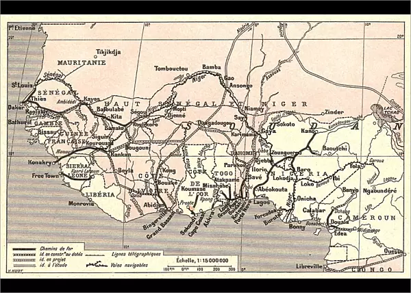
Voies de communication de l'Afrique occidentale francaise; L'Ouest Africain, 1914. Creator: Unknown
Voies de communication de l'Afrique occidentale francaise; L'Ouest Africain, 1914. From "Grande Geographie Bong Illustree", 1914
Heritage Images features heritage image collections
Media ID 36295649
© The Print Collector/Heritage Images
Atlantic Ocean Cartography Colonies Colony Communication Infrastructure Map Making Mapmaking Ocean Railway Line Railway Lines Railway Track Railway Tracks Roads Route Thoroughfare Train Track West Africa West African Connections Routes
A4 (29.7 x 21cm) Poster Print
Step back in time with our vintage poster print from the Media Storehouse collection. This captivating image, titled "Voies de communication de l'Afrique occidentale francaise; L'Ouest Africain," dates back to 1914. Originally published in the renowned French geography magazine, Grande Geographie Bong Illustree, this poster showcases the communication routes of French West Africa. The intricate detail and rich colors bring history to life, making this an excellent addition to any decor or classroom. Unknown creator, this rare piece is a testament to the past and a reminder of the fascinating history of African exploration.
Premium quality poster prints are printed on luxurious semi-gloss satin 270 gsm paper. Our meticulously crafted poster prints offer an affordable option for decorating any space, making them ideal for living rooms, bedrooms, offices and beyond. To ensure your poster arrives in good condition, we roll and send them in strong mailing tubes.
Poster prints are budget friendly enlarged prints in standard poster paper sizes (A0, A1, A2, A3 etc). Whilst poster paper is sometimes thinner and less durable than our other paper types, they are still ok for framing and should last many years. Our Archival Quality Photo Prints and Fine Art Paper Prints are printed on higher quality paper and the choice of which largely depends on your budget.
Estimated Image Size (if not cropped) is 30.3cm x 19.5cm (11.9" x 7.7")
Estimated Product Size is 30.3cm x 21.6cm (11.9" x 8.5")
These are individually made so all sizes are approximate
Artwork printed orientated as per the preview above, with landscape (horizontal) orientation to match the source image.
FEATURES IN THESE COLLECTIONS
> Maps and Charts
> Related Images
> Popular Themes
> Railway Posters
> Transportation
> Trains
EDITORS COMMENTS
Voies de communication de l'Afrique occidentale francaise; L'Ouest Africain, 1894" is a captivating print depicting the communication routes of French West Africa in the early 1910s. The image, created by an unknown artist, was published in "Grande Geographie Illustree" in 1914. The print showcases the extensive network of transportation infrastructure that connected the French colonies in West Africa to each other and to the Atlantic Ocean. The intricate web of railway lines, train tracks, and roads crisscross the map, forming a complex network that facilitated the movement of people, goods, and ideas. The Atlantic Ocean is depicted along the edge of the map, with the coastline of West Africa clearly visible. The railways, which were a key component of French colonialism, are prominently featured, stretching from the coastal regions inland. The print also highlights the importance of rivers as transportation routes, with several major waterways marked on the map. The map is a testament to the ambition and reach of French colonial power in Africa during the early 20th century. It demonstrates the significant investment made by the French in building infrastructure to facilitate the exploitation of resources and the administration of their colonies. The print also underscores the importance of communication and transportation in the colonial project, as it enabled the movement of people, goods, and ideas between the metropole and its colonies. Despite the unknown origin of the print, it provides valuable insights into the geography and history of French West Africa during a pivotal period in its colonial history. The intricate detail and high-quality engraving make it a fascinating addition to any collection of historical maps or Africana.
MADE IN AUSTRALIA
Safe Shipping with 30 Day Money Back Guarantee
FREE PERSONALISATION*
We are proud to offer a range of customisation features including Personalised Captions, Color Filters and Picture Zoom Tools
SECURE PAYMENTS
We happily accept a wide range of payment options so you can pay for the things you need in the way that is most convenient for you
* Options may vary by product and licensing agreement. Zoomed Pictures can be adjusted in the Cart.