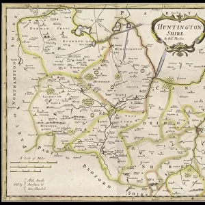
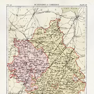
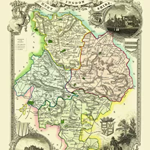
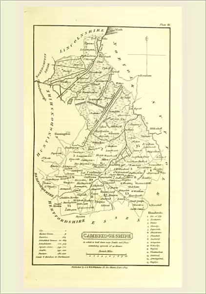
Poster Print : Cambridgeshire map, A Topographical Dictionary of the United Kingdom, UK, 19th century


![]()
Poster Prints from Liszt Collection
Cambridgeshire map, A Topographical Dictionary of the United Kingdom, UK, 19th century
Cambridgeshire map, A Topographical Dictionary of the United Kingdom, UK, 19th century engraving
Liszt Collection of nineteenth-century engravings and images to browse and enjoy
Media ID 12805549
© Quint Lox Limited
Cambridgeshire Topographical Dictionary United Kingdom
A1 (84.1 x 59.4cm) Poster Print
Step back in time with our exquisite selection of antique poster prints from the Media Storehouse. This captivating piece showcases a detailed 19th century engraving of a map of Cambridgeshire from A Topographical Dictionary of the United Kingdom. Originating from the esteemed Liszt Collection, this vintage print boasts intricate lines and rich details, transporting you back to an era of exploration and discovery. Perfect for history enthusiasts, map collectors, or those seeking to add a touch of charm to their living space, this timeless print is a must-have addition to any decor.
Premium quality poster prints are printed on luxurious glossy or matte 270 gsm paper. Our meticulously crafted poster prints offer an affordable option for decorating any space, making them ideal for living rooms, bedrooms, offices and beyond. To ensure your poster arrives in good condition, we roll and send them in strong mailing tubes.
Poster prints are budget friendly enlarged prints in standard poster paper sizes (A0, A1, A2, A3 etc). Whilst poster paper is sometimes thinner and less durable than our other paper types, they are still ok for framing and should last many years. Our Archival Quality Photo Prints and Fine Art Paper Prints are printed on higher quality paper and the choice of which largely depends on your budget.
Estimated Image Size (if not cropped) is 49.3cm x 84.6cm (19.4" x 33.3")
Estimated Product Size is 59.6cm x 84.6cm (23.5" x 33.3")
These are individually made so all sizes are approximate
Artwork printed orientated as per the preview above, with portrait (vertical) orientation to match the source image.
EDITORS COMMENTS
This 19th-century engraving of the Cambridgeshire map is a true testament to the rich history and intricate beauty of this region in the United Kingdom. As part of A Topographical Dictionary of the United Kingdom, this print offers a glimpse into an era long gone, where hand-drawn maps were meticulously crafted with utmost precision. The detailed topography showcased in this print allows us to explore every nook and cranny of Cambridgeshire's diverse landscape. From its rolling hills and lush meadows to its winding rivers and charming villages, each element on this map tells a story waiting to be discovered. As we delve into the past through this enchanting piece, we can imagine how life must have been for the inhabitants of Cambridgeshire during that time. The hustle and bustle of market towns, the tranquility found in nature's embrace, and perhaps even some hidden secrets tucked away within these ancient borders. Beyond its historical significance, this print from Liszt Collection serves as a reminder that our world is ever-evolving. It prompts us to reflect on how far we have come since those days when maps like these were essential tools for exploration and navigation. Whether you are an avid historian or simply appreciate artistry at its finest, let your imagination wander as you gaze upon this remarkable engraving—a window into both Cambridgeshire's past and our own fascination with preserving history for generations to come.
MADE IN AUSTRALIA
Safe Shipping with 30 Day Money Back Guarantee
FREE PERSONALISATION*
We are proud to offer a range of customisation features including Personalised Captions, Color Filters and Picture Zoom Tools
SECURE PAYMENTS
We happily accept a wide range of payment options so you can pay for the things you need in the way that is most convenient for you
* Options may vary by product and licensing agreement. Zoomed Pictures can be adjusted in the Cart.