Poster Print > Maps and Charts > World
Poster Print : Giant World Map


![]()
Poster Prints from Map Marketing
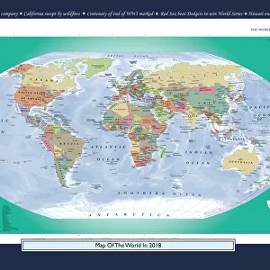
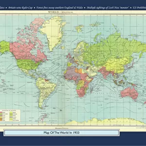
Giant World Map
This extra-large map of the world is based on the Mercator Projection and is ideal for both business and educational purposes, or even simply as a stunning wall display. The exceptionally clear format shows political boundaries with each country depicted in a different vibrant colour to its immediate neighbours. The world map is further enhanced by coloured relief and ocean depth depictions, thus adding a striking textured effect and providing an element of physical representation to this political map. International time zones are depicted along the bottom of the map. Cities are depicted in five population bands, and the map also shows principal roads and railways, international boundaries (indicating those which are disputed) as well as state boundaries within countries. Capital cities of both countries and states are displayed, and international airports and seaports are shown
Media ID 19949308
© Map Marketing Ltd
A4 (29.7 x 21cm) Poster Print
Premium quality poster prints are printed on luxurious semi-gloss satin 270 gsm paper. Our meticulously crafted poster prints offer an affordable option for decorating any space, making them ideal for living rooms, bedrooms, offices and beyond. To ensure your poster arrives in good condition, we roll and send them in strong mailing tubes.
Poster prints are budget friendly enlarged prints in standard poster paper sizes (A0, A1, A2, A3 etc). Whilst poster paper is sometimes thinner and less durable than our other paper types, they are still ok for framing and should last many years. Our Archival Quality Photo Prints and Fine Art Paper Prints are printed on higher quality paper and the choice of which largely depends on your budget.
Estimated Image Size (if not cropped) is 30.3cm x 19.6cm (11.9" x 7.7")
Estimated Product Size is 30.3cm x 21.6cm (11.9" x 8.5")
These are individually made so all sizes are approximate
Artwork printed orientated as per the preview above, with landscape (horizontal) orientation to match the source image.
FEATURES IN THESE COLLECTIONS
> Maps and Charts
> Popular Maps
> Maps and Charts
> Related Images
> Maps and Charts
> World
> Popular Themes
> Railway Posters
MADE IN AUSTRALIA
Safe Shipping with 30 Day Money Back Guarantee
FREE PERSONALISATION*
We are proud to offer a range of customisation features including Personalised Captions, Color Filters and Picture Zoom Tools
SECURE PAYMENTS
We happily accept a wide range of payment options so you can pay for the things you need in the way that is most convenient for you
* Options may vary by product and licensing agreement. Zoomed Pictures can be adjusted in the Cart.