Poster Print > Europe > United Kingdom > England > London > Royalty
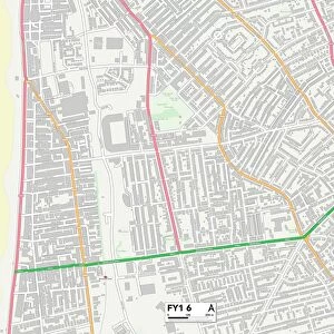
Poster Print : Old Map of Blackpool 1898 from the Royal Atlas by Bartholomew


![]()
Poster Prints from MapSeeker
Old Map of Blackpool 1898 from the Royal Atlas by Bartholomew
A fine very detailed plan of the Town of Blackpool remastered from an original contained within " The Royal Atlas of England and Wales" ; edited by J.G. Bartholomew, published by George Newnes, Limited, London
Welcome to the Mapseeker Image library and enter an historic gateway to one of the largest on-line collections of Historic Maps, Nostalgic Views, Vista's and Panorama's from a World gone by.
Media ID 20347626
Bartholomew Bartholomew Map Historic Map Old Town Plan Royal Atlas Royal Atlas Map Blackpool
A4 (29.7 x 21cm) Poster Print
Step back in time with our exquisite Old Map of Blackpool 1898 from the Royal Atlas by Bartholomew. Meticulously remastered from the original contained within "The Royal Atlas of England and Wales," this poster print offers a fascinating glimpse into the history of Blackpool as it appeared over a century ago. With intricate details and vibrant colors, this vintage map is a must-have for history enthusiasts, locals, and anyone who appreciates the charm of bygone eras. Bring the rich heritage of Blackpool into your home or office with this beautifully preserved piece of cartographic history.
Premium quality poster prints are printed on luxurious semi-gloss satin 270 gsm paper. Our meticulously crafted poster prints offer an affordable option for decorating any space, making them ideal for living rooms, bedrooms, offices and beyond. To ensure your poster arrives in good condition, we roll and send them in strong mailing tubes.
Poster prints are budget friendly enlarged prints in standard poster paper sizes (A0, A1, A2, A3 etc). Whilst poster paper is sometimes thinner and less durable than our other paper types, they are still ok for framing and should last many years. Our Archival Quality Photo Prints and Fine Art Paper Prints are printed on higher quality paper and the choice of which largely depends on your budget.
Estimated Image Size (if not cropped) is 30.3cm x 20.2cm (11.9" x 8")
Estimated Product Size is 30.3cm x 21.6cm (11.9" x 8.5")
These are individually made so all sizes are approximate
Artwork printed orientated as per the preview above, with landscape (horizontal) orientation to match the source image.
FEATURES IN THESE COLLECTIONS
> MapSeeker
> British Town And City Plans
> English & Welsh PORTFOLIO
> Arts
> Photorealistic artworks
> Detailed art pieces
> Masterful detailing in art
> Europe
> United Kingdom
> England
> London
> Royalty
> Europe
> United Kingdom
> England
> Maps
> Europe
> United Kingdom
> Wales
> Maps
> Europe
> United Kingdom
> Wales
> Posters
> Maps and Charts
> Related Images
> Maps and Charts
> Wales
EDITORS COMMENTS
This stunning print showcases the "Old Map of Blackpool 1898" from the renowned Royal Atlas by Bartholomew. Remastered from an original contained within "The Royal Atlas of England and Wales" edited by J. G. Bartholomew and published by George Newnes, Limited in London, this map offers a fascinating glimpse into the past. With its fine details and intricate design, this historic map provides a comprehensive town plan of Blackpool during that era. It takes you on a journey through time, allowing you to explore the streets, landmarks, and layout of this vibrant coastal town as it was over a century ago. As you delve into this old town plan, you'll discover how Blackpool has evolved throughout history. From its bustling promenade to iconic attractions like the Tower Ballroom or Winter Gardens Theatre, every corner holds stories waiting to be uncovered. Whether you're a history enthusiast or simply curious about Blackpool's heritage, this print is sure to captivate your imagination. Its authentic depiction invites contemplation on how urban landscapes have transformed over time while preserving their unique charm. Perfect for home decor or educational purposes, this high-quality reproduction brings together artistry and historical significance in one captivating piece. Let yourself be transported back in time with this remarkable remastered map - an invaluable addition to any collection celebrating cartography or local history enthusiasts alike!
MADE IN AUSTRALIA
Safe Shipping with 30 Day Money Back Guarantee
FREE PERSONALISATION*
We are proud to offer a range of customisation features including Personalised Captions, Color Filters and Picture Zoom Tools
SECURE PAYMENTS
We happily accept a wide range of payment options so you can pay for the things you need in the way that is most convenient for you
* Options may vary by product and licensing agreement. Zoomed Pictures can be adjusted in the Cart.