Poster Print > Europe > France > Paris > Maps
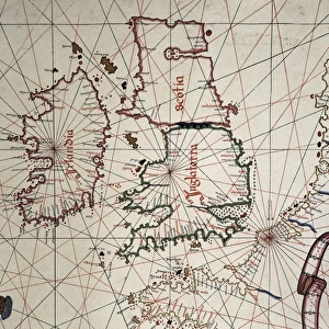
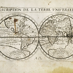
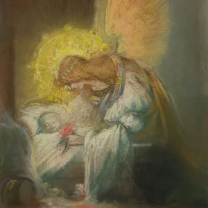
Poster Print : The Caverio Map or Caveri Map, circa 1505. This


![]()
Poster Prints from Mary Evans Picture Library
The Caverio Map or Caveri Map, circa 1505. This
The Caverio Map or Caveri Map, circa 1505. This map was one of the primary sources used to make the Waldseem� map. Miniature Painting. FRANCE. Paris. National Library
Mary Evans Picture Library makes available wonderful images created for people to enjoy over the centuries
Media ID 8282169
© Mary Evans Picture Library 2015 - https://copyrighthub.org/s0/hub1/creation/maryevans/MaryEvansPictureID/10682011
Illuminated Manuscript Manuscripts Miniatures Primary Sources Nicolay
A1 (84.1 x 59.4cm) Poster Print
Introducing the captivating selection of poster prints from Media Storehouse, featuring the exquisite "The Caverio Map or Caveri Map, circa 1505." This rare and intriguing map, sourced from Mary Evans Prints Online, holds historical significance as it was one of the primary influences for the creation of the Waldseemüller map. With its miniature painting style and origin in Paris, France, this National Library treasure is now available in beautiful, high-quality poster prints. Transport yourself back in time with this stunning piece of cartographic history. Perfect for decorating your home or office, these poster prints make for a thought-provoking conversation starter and a beautiful addition to any space.
Premium quality poster prints are printed on luxurious glossy or matte 270 gsm paper. Our meticulously crafted poster prints offer an affordable option for decorating any space, making them ideal for living rooms, bedrooms, offices and beyond. To ensure your poster arrives in good condition, we roll and send them in strong mailing tubes.
Poster prints are budget friendly enlarged prints in standard poster paper sizes (A0, A1, A2, A3 etc). Whilst poster paper is sometimes thinner and less durable than our other paper types, they are still ok for framing and should last many years. Our Archival Quality Photo Prints and Fine Art Paper Prints are printed on higher quality paper and the choice of which largely depends on your budget.
Estimated Image Size (if not cropped) is 84.6cm x 46.4cm (33.3" x 18.3")
Estimated Product Size is 84.6cm x 59.6cm (33.3" x 23.5")
These are individually made so all sizes are approximate
Artwork printed orientated as per the preview above, with landscape (horizontal) orientation to match the source image.
FEATURES IN THESE COLLECTIONS
> Europe
> France
> Paris
> Maps
> Europe
> France
> Paris
> Related Images
> Maps and Charts
> Related Images
EDITORS COMMENTS
1. Title: The Caverio Map, Circa 1505: A Glimpse into Early Cartography and Manuscript Illumination The Caverio Map, also known as the Caveri Map, is an exquisite example of early cartography and manuscript illumination, dating back to approximately 1505. This intricately detailed and beautifully colored miniature painting is currently housed in the National Library of France in Paris. As one of the primary sources used to create the renowned Waldseemüller map, the Caverio Map holds significant historical importance. The Waldseemüller map, produced in 1507, is considered the first map to depict the Americas with the names "America" and "New World." The Caverio Map showcases an impressive level of detail, with various geographical features, including rivers, mountains, and coastlines, meticulously rendered. The map is horizontal in orientation, and its vibrant colors and illuminated elements add a striking visual appeal. The map's creation was likely influenced by the extensive travel and exploration of the late 15th and early 16th centuries. The Caverio Map reflects the contemporary understanding of the world at that time, with some inaccuracies and misconceptions that were common during the era. This magnificent manuscript is a testament to the artistic and cartographic achievements of the period. Its intricate details and historical significance make it an essential piece in the study of early cartography and manuscript illumination. The Caverio Map continues to captivate scholars, historians, and enthusiasts alike, offering a fascinating glimpse into the world of exploration and discovery during the Renaissance era.
MADE IN AUSTRALIA
Safe Shipping with 30 Day Money Back Guarantee
FREE PERSONALISATION*
We are proud to offer a range of customisation features including Personalised Captions, Color Filters and Picture Zoom Tools
SECURE PAYMENTS
We happily accept a wide range of payment options so you can pay for the things you need in the way that is most convenient for you
* Options may vary by product and licensing agreement. Zoomed Pictures can be adjusted in the Cart.