Poster Print > North America > Canada > Maps
Poster Print : Map showing distant early warning line for defence


![]()
Poster Prints from Mary Evans Picture Library
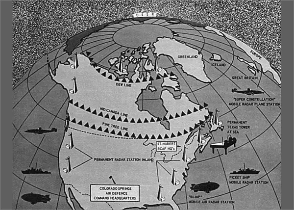
Map showing distant early warning line for defence
Distant early warning line (DEW line) of all-round radar defence. A map of North America, showing the various systems and devices of Conad, the Continental Air Defence Command which is responsible for the protection of North America. Date: 1958
Mary Evans Picture Library makes available wonderful images created for people to enjoy over the centuries
Media ID 14157494
© Illustrated London News Ltd/Mary Evans
1958 Cold Command Continental Defence Defense Devices Distant Maps Pine Protection Radar System Systems Warning
A4 (29.7 x 21cm) Poster Print
Introducing the Media Storehouse range of high-quality poster prints featuring an intriguing image of a map showing the Distant Early Warning (DEW) line for defence. This captivating visual representation, sourced from Mary Evans Prints Online, provides a unique insight into the all-round radar defence systems and devices of the Conad organization. Ideal for enhancing the decor of your office or home, this poster print is a must-have for history enthusiasts, military aficionados, or anyone interested in the history of defense technology. With its crisp and vibrant colors, this print is sure to make a statement and spark intriguing conversations. Order yours today and bring a piece of historical significance into your space.
Premium quality poster prints are printed on luxurious semi-gloss satin 270 gsm paper. Our meticulously crafted poster prints offer an affordable option for decorating any space, making them ideal for living rooms, bedrooms, offices and beyond. To ensure your poster arrives in good condition, we roll and send them in strong mailing tubes.
Poster prints are budget friendly enlarged prints in standard poster paper sizes (A0, A1, A2, A3 etc). Whilst poster paper is sometimes thinner and less durable than our other paper types, they are still ok for framing and should last many years. Our Archival Quality Photo Prints and Fine Art Paper Prints are printed on higher quality paper and the choice of which largely depends on your budget.
Estimated Product Size is 30.3cm x 21.6cm (11.9" x 8.5")
These are individually made so all sizes are approximate
Artwork printed orientated as per the preview above, with landscape (horizontal) orientation to match the source image.
FEATURES IN THESE COLLECTIONS
> Maps and Charts
> Early Maps
> Maps and Charts
> Related Images
> North America
> Canada
> Maps
> North America
> Canada
> Related Images
> North America
> Related Images
> North America
> United States of America
> Maps
EDITORS COMMENTS
This historic map from 1958 offers a fascinating glimpse into the intricate Distant Early Warning (DEW) line system established by the Continental Air Defense Command (CONAD) to safeguard North America during the Cold War. The map illustrates the extensive network of radar installations and devices that formed the first line of defense against potential air attacks from the Soviet Union. The DEW line, represented by the red dots on the map, stretched over 1,500 miles from Alaska to Newfoundland, with radar stations placed approximately 100 miles apart. The radar systems, depicted as small circles, were designed to detect incoming aircraft at a distance of up to 250 miles, providing early warning and allowing for an effective response. The map also highlights the strategic importance of Canada in the defense of North America, with several radar installations located in the northern regions of the country. The map's title, "Distant Early Warning Line," is inscribed at the bottom, along with the date 1958. The DEW line was a crucial component of the American defense system during the 1950s, representing a significant investment in technology and military infrastructure. The system's effectiveness was demonstrated during the Cuban Missile Crisis in 1962, when the radar installations detected the presence of Soviet missiles in Cuba, leading to a tense standoff between the United States and the Soviet Union. This map provides a unique perspective on the history of Cold War defense strategies and the technological innovations that shaped the geopolitical landscape of the mid-20th century. The pine trees and mid-century design elements add to the nostalgic charm of this historical artifact.
MADE IN AUSTRALIA
Safe Shipping with 30 Day Money Back Guarantee
FREE PERSONALISATION*
We are proud to offer a range of customisation features including Personalised Captions, Color Filters and Picture Zoom Tools
SECURE PAYMENTS
We happily accept a wide range of payment options so you can pay for the things you need in the way that is most convenient for you
* Options may vary by product and licensing agreement. Zoomed Pictures can be adjusted in the Cart.