Poster Print > Animals > Mammals > Muridae > Desert Mouse
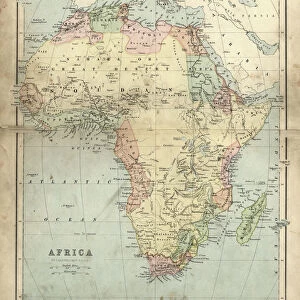
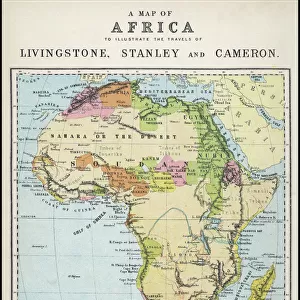
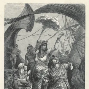
Poster Print : Map of Africa illustrating travels of explorers


![]()
Poster Prints from Mary Evans Picture Library
Map of Africa illustrating travels of explorers
A map of Africa which illustrates the travels of the explorers Livingstone, Stanley and Cameron. Date: 19th Century
Mary Evans Picture Library makes available wonderful images created for people to enjoy over the centuries
Media ID 20141037
© Bubblepunk
Arabia Cameron Cartography Coding Desert Exploration Explorer Explorers Illustrating Livingstone Madagascar Maps Mediterranean Nubia Persia Sahara Stanley Sudan Travels
A4 (29.7 x 21cm) Poster Print
Discover the rich history of African exploration with our stunning Map of Africa Poster Print from Media Storehouse, featuring illustrations of the travels of legendary explorers David Livingstone, Henry Morton Stanley, and Pierre Savorgnan de Brazza. This captivating vintage map, sourced from Mary Evans Prints Online, takes you on a journey through the 19th century as these intrepid adventurers charted new territories and expanded our understanding of the African continent. Bring a piece of historical exploration into your home or office and transport yourself back in time with this beautiful and intriguing poster print.
Premium quality poster prints are printed on luxurious semi-gloss satin 270 gsm paper. Our meticulously crafted poster prints offer an affordable option for decorating any space, making them ideal for living rooms, bedrooms, offices and beyond. To ensure your poster arrives in good condition, we roll and send them in strong mailing tubes.
Poster prints are budget friendly enlarged prints in standard poster paper sizes (A0, A1, A2, A3 etc). Whilst poster paper is sometimes thinner and less durable than our other paper types, they are still ok for framing and should last many years. Our Archival Quality Photo Prints and Fine Art Paper Prints are printed on higher quality paper and the choice of which largely depends on your budget.
Estimated Product Size is 21.6cm x 30.3cm (8.5" x 11.9")
These are individually made so all sizes are approximate
Artwork printed orientated as per the preview above, with landscape (horizontal) or portrait (vertical) orientation to match the source image.
FEATURES IN THESE COLLECTIONS
> Mary Evans Prints Online
> Egypt
> Mary Evans Prints Online
> New Images July 2020
> Africa
> Egypt
> Related Images
> Africa
> Madagascar
> Maps
> Africa
> Madagascar
> Related Images
> Africa
> Related Images
> Africa
> Sudan
> Related Images
> Animals
> Mammals
> Muridae
> Desert Mouse
> Arts
> Artists
> O
> Oceanic Oceanic
EDITORS COMMENTS
This stunning 19th century map of Africa, available as a print from Mary Evans Prints Online, provides a captivating visual representation of the intrepid explorations that transformed our understanding of the African continent. Illustrating the travels of renowned explorers David Livingstone, Henry Morton Stanley, and Pierre Savorgnan de Brazza, this map is a testament to the spirit of discovery that characterized the Victorian era. The map, richly detailed and vibrantly colored, charts the explorers' routes across the vast expanse of Africa, from the arid Sahara Desert in the north to the lush rainforests of the Congo Basin in the south. The Sahara Desert is coded in sandy hues, while the verdant Nile Valley and the fertile lands of Egypt and Nubia are depicted in lush greens. Madagascar, an island nation off the eastern coast of Africa, is shown in earthy browns and greens, while the Persian Gulf and the Arabian Peninsula are rendered in warm sands and blues. The Mediterranean Sea and the Atlantic Ocean frame the western and northern edges of the map, their deep blues contrasting with the golden sands of the desert and the lush greens of the African interior. The map's intricate cartography reveals the explorers' routes, from Livingstone's travels in Southern Africa to Stanley's famous encounter with Livingstone in Ujiji, and de Brazza's exploration of the Congo Basin. This map is not only a historical document, but also a work of art, capturing the imagination and wonder of a time when the world seemed full of unexplored mysteries. It invites us to explore the rich history of Africa and the intrepid explorers who helped shape our understanding of this fascinating continent.
MADE IN AUSTRALIA
Safe Shipping with 30 Day Money Back Guarantee
FREE PERSONALISATION*
We are proud to offer a range of customisation features including Personalised Captions, Color Filters and Picture Zoom Tools
SECURE PAYMENTS
We happily accept a wide range of payment options so you can pay for the things you need in the way that is most convenient for you
* Options may vary by product and licensing agreement. Zoomed Pictures can be adjusted in the Cart.