Poster Print > Europe > Norway > Maps
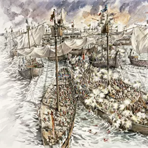
Poster Print : WW1 naval blockades


![]()
Poster Prints from Mary Evans Picture Library
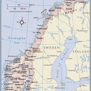
WW1 naval blockades
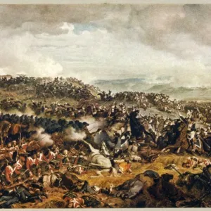
Map of English and German naval blockades around Britain, France, Belgium, Germany, Denmark and Norway
Mary Evans Picture Library makes available wonderful images created for people to enjoy over the centuries
Media ID 4479275
© Mary Evans Picture Library 2015 - https://copyrighthub.org/s0/hub1/creation/maryevans/MaryEvansPictureID/10470768
Access Denmark Maritime Norway Routes Shipping Supply Blockades Ww 1
A4 (29.7 x 21cm) Poster Print
"Step back in time with our captivating WW1 Naval Blockades poster print from Media Storehouse. This historic image, sourced from Mary Evans Prints Online, depicts a map of the English and German naval blockades during World War I. Engagingly illustrated, this print showcases the strategic locations around Britain, France, Belgium, Germany, Denmark, and Norway where naval forces clashed in a battle for maritime supremacy. Perfectly suited for history enthusiasts, educators, or anyone with an appreciation for the past, this poster print adds a touch of historical significance to any room. Order yours today and bring a piece of history into your home or office."
Premium quality poster prints are printed on luxurious semi-gloss satin 270 gsm paper. Our meticulously crafted poster prints offer an affordable option for decorating any space, making them ideal for living rooms, bedrooms, offices and beyond. To ensure your poster arrives in good condition, we roll and send them in strong mailing tubes.
Poster prints are budget friendly enlarged prints in standard poster paper sizes (A0, A1, A2, A3 etc). Whilst poster paper is sometimes thinner and less durable than our other paper types, they are still ok for framing and should last many years. Our Archival Quality Photo Prints and Fine Art Paper Prints are printed on higher quality paper and the choice of which largely depends on your budget.
Estimated Product Size is 21.6cm x 30.3cm (8.5" x 11.9")
These are individually made so all sizes are approximate
Artwork printed orientated as per the preview above, with portrait (vertical) orientation to match the source image.
FEATURES IN THESE COLLECTIONS
> Europe
> Belgium
> Related Images
> Europe
> Denmark
> Related Images
EDITORS COMMENTS
This historic map from the First World War era depicts the naval blockades instituted by both the Allied Powers, primarily Britain, and the Central Powers, primarily Germany, around Europe's North Sea and Atlantic coastlines. The map highlights the strategic locations of England, France, Belgium, Germany, Denmark, and Norway, with intricate detail showcasing the maritime routes and access points that were crucial to the supply lines of each nation. During the early stages of the First World War, the British Royal Navy implemented a blockade of the North Sea and the English Channel to prevent German military and commercial ships from accessing the continent. This naval blockade aimed to cut off Germany's access to essential resources, particularly food and raw materials, in an attempt to weaken the German war effort. In response, Germany established its own naval blockade of the British Isles, targeting the vital shipping lanes that supplied Britain with essential resources from its colonies and neutral countries. This blockade, known as the "Hunger Blockade," caused significant hardships for the British population, leading to food shortages and rising prices. The map also illustrates the Danish and Norwegian waters, which were subject to intense naval activity due to their strategic locations. Denmark, a neutral country, was subjected to pressure from both sides, with the British and German navies vying for control of the waters. Norway, which had a significant fishing industry, was also a target for naval blockades due to its rich fishing grounds. This map offers a unique perspective on the maritime warfare that characterized the First World War, highlighting the complex interplay of naval strategy, resource acquisition, and diplomacy that defined the conflict in Europe and beyond.
MADE IN AUSTRALIA
Safe Shipping with 30 Day Money Back Guarantee
FREE PERSONALISATION*
We are proud to offer a range of customisation features including Personalised Captions, Color Filters and Picture Zoom Tools
SECURE PAYMENTS
We happily accept a wide range of payment options so you can pay for the things you need in the way that is most convenient for you
* Options may vary by product and licensing agreement. Zoomed Pictures can be adjusted in the Cart.