Jigsaw Puzzle > Europe > Norway > Maps
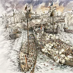
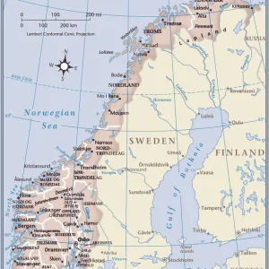
Jigsaw Puzzle : WW1 naval blockades


![]()
Jigsaw Puzzles from Mary Evans Picture Library
WW1 naval blockades
Map of English and German naval blockades around Britain, France, Belgium, Germany, Denmark and Norway
Mary Evans Picture Library makes available wonderful images created for people to enjoy over the centuries
Media ID 4479275
© Mary Evans Picture Library 2015 - https://copyrighthub.org/s0/hub1/creation/maryevans/MaryEvansPictureID/10470768
Access Denmark Maritime Norway Routes Shipping Supply Blockades Ww 1
Jigsaw Puzzle (500 Pieces)
Discover history through the captivating challenge of our Media Storehouse WW1 Naval Blockades Jigsaw Puzzle. This intricately detailed puzzle, featuring a historic map from Mary Evans Prints Online, transports you back in time to the tense waters of the First World War. Navigate the English and German naval blockades around Britain, France, Belgium, Germany, Denmark, and Norway as you piece together this beautifully illustrated puzzle. A perfect activity for history enthusiasts, families, or anyone seeking a thoughtful and engaging pastime. Immerse yourself in the rich tapestry of history, one puzzle piece at a time.
500 piece puzzles are custom made in Australia and hand-finished on 100% recycled 1.6mm thick laminated puzzle boards. There is a level of repetition in jigsaw shapes with each matching piece away from its pair. The completed puzzle measures 40x51cm and is delivered packaged in an attractive presentation box specially designed to fit most mail slots with a unique magnetic lid
Jigsaw Puzzles are an ideal gift for any occasion
Estimated Product Size is 40.3cm x 50.7cm (15.9" x 20")
These are individually made so all sizes are approximate
Artwork printed orientated as per the preview above, with landscape (horizontal) or portrait (vertical) orientation to match the source image.
FEATURES IN THESE COLLECTIONS
> Europe
> Belgium
> Related Images
> Europe
> Denmark
> Related Images
EDITORS COMMENTS
This historic map from the First World War era depicts the naval blockades instituted by both the Allied Powers, primarily Britain, and the Central Powers, primarily Germany, around Europe's North Sea and Atlantic coastlines. The map highlights the strategic locations of England, France, Belgium, Germany, Denmark, and Norway, with intricate detail showcasing the maritime routes and access points that were crucial to the supply lines of each nation. During the early stages of the First World War, the British Royal Navy implemented a blockade of the North Sea and the English Channel to prevent German military and commercial ships from accessing the continent. This naval blockade aimed to cut off Germany's access to essential resources, particularly food and raw materials, in an attempt to weaken the German war effort. In response, Germany established its own naval blockade of the British Isles, targeting the vital shipping lanes that supplied Britain with essential resources from its colonies and neutral countries. This blockade, known as the "Hunger Blockade," caused significant hardships for the British population, leading to food shortages and rising prices. The map also illustrates the Danish and Norwegian waters, which were subject to intense naval activity due to their strategic locations. Denmark, a neutral country, was subjected to pressure from both sides, with the British and German navies vying for control of the waters. Norway, which had a significant fishing industry, was also a target for naval blockades due to its rich fishing grounds. This map offers a unique perspective on the maritime warfare that characterized the First World War, highlighting the complex interplay of naval strategy, resource acquisition, and diplomacy that defined the conflict in Europe and beyond.
MADE IN AUSTRALIA
Safe Shipping with 30 Day Money Back Guarantee
FREE PERSONALISATION*
We are proud to offer a range of customisation features including Personalised Captions, Color Filters and Picture Zoom Tools
SECURE PAYMENTS
We happily accept a wide range of payment options so you can pay for the things you need in the way that is most convenient for you
* Options may vary by product and licensing agreement. Zoomed Pictures can be adjusted in the Cart.