Poster Print > Maps and Charts > Related Images
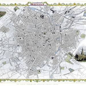
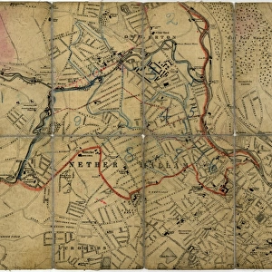
Poster Print : Plan of Sheffield c. 1880


![]()
Poster Prints from Sheffield City Archives
Plan of Sheffield c. 1880
Original at Sheffield Local Studies Librarys 83 M
Sheffield City Archives and Local Studies Library has an unrivalled collection of images of Sheffield, England
Media ID 14086414
© Sheffield City Council
A4 (29.7 x 21cm) Poster Print
Step back in time with our exquisite Media Storehouse Poster Prints, featuring a captivating image of Sheffield's rich history. This particular print showcases an intricately detailed Plan of Sheffield from around 1880, sourced directly from the Sheffield City Archives (83 M). Each print is meticulously produced, bringing the historical charm of this vintage map to your home or office. Transport yourself to another era and add a touch of timeless elegance to your space with our authentic and high-quality poster prints.
Premium quality poster prints are printed on luxurious semi-gloss satin 270 gsm paper. Our meticulously crafted poster prints offer an affordable option for decorating any space, making them ideal for living rooms, bedrooms, offices and beyond. To ensure your poster arrives in good condition, we roll and send them in strong mailing tubes.
Poster prints are budget friendly enlarged prints in standard poster paper sizes (A0, A1, A2, A3 etc). Whilst poster paper is sometimes thinner and less durable than our other paper types, they are still ok for framing and should last many years. Our Archival Quality Photo Prints and Fine Art Paper Prints are printed on higher quality paper and the choice of which largely depends on your budget.
Estimated Image Size (if not cropped) is 30.3cm x 18.9cm (11.9" x 7.4")
Estimated Product Size is 30.3cm x 21.6cm (11.9" x 8.5")
These are individually made so all sizes are approximate
Artwork printed orientated as per the preview above, with landscape (horizontal) orientation to match the source image.
FEATURES IN THESE COLLECTIONS
> Maps and Charts
> Related Images
> Sheffield City Archives
> Maps and Plans
Plan of Sheffield c. 1880 - A Glimpse into the Industrial Heartland
EDITORS COMMENTS
. This print takes us back in time to the bustling city of Sheffield during the late 19th century. The image showcases a meticulously detailed plan, originally housed at the Sheffield Local Studies Librarys (83 M), offering an intriguing glimpse into the city's rich history and urban development. Sheffield, renowned for its steel industry, was rapidly transforming into a thriving industrial hub during this period. This plan serves as a valuable historical artifact, illustrating how the cityscape evolved amidst rapid growth and technological advancements. The intricate details depicted on this map highlight various landmarks that shaped Sheffield's identity at that time. From sprawling factories and workshops to bustling markets and residential areas, it encapsulates both the commercial prowess and everyday life of its inhabitants. Beyond its architectural significance, this photograph also invites reflection on social dynamics prevalent in Victorian society. It prompts contemplation about working conditions endured by laborers who contributed to Sheffield's rise as an industrial powerhouse. Preserved within Sheffield City Archives, this remarkable print offers researchers and enthusiasts alike an opportunity to delve deeper into understanding how cities evolve over time. It reminds us of our collective heritage while igniting curiosity about those who came before us. As we gaze upon this snapshot from yesteryears, let us appreciate not only the craftsmanship behind such meticulous planning but also recognize how it captures a pivotal moment in Sheffield's past—a testament to resilience, innovation, and community spirit that
MADE IN AUSTRALIA
Safe Shipping with 30 Day Money Back Guarantee
FREE PERSONALISATION*
We are proud to offer a range of customisation features including Personalised Captions, Color Filters and Picture Zoom Tools
SECURE PAYMENTS
We happily accept a wide range of payment options so you can pay for the things you need in the way that is most convenient for you
* Options may vary by product and licensing agreement. Zoomed Pictures can be adjusted in the Cart.