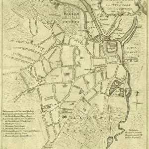
Poster Print > Sheffield City Archives > Maps and Plans > Sheffield OS maps
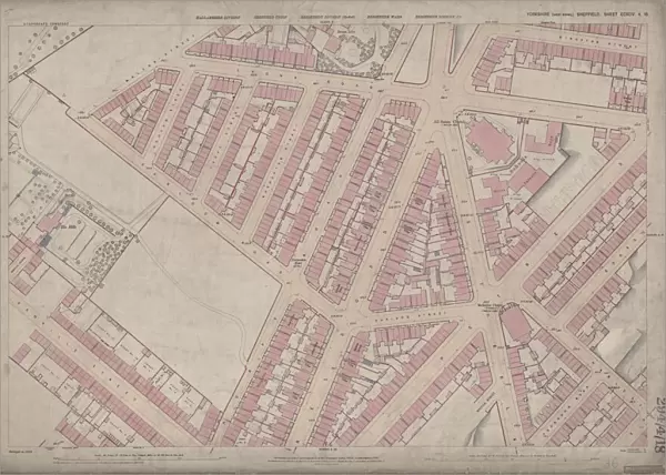
Poster Print : Ordnance Survey Map, Ellesmere Road / Lyons Road area of Sheffield, 1889 (Yorkshire sheet number 294. 4. 18)
")


![]()
Poster Prints from Sheffield City Archives
Ordnance Survey Map, Ellesmere Road / Lyons Road area of Sheffield, 1889 (Yorkshire sheet number 294. 4. 18)
This map features:
Top left: Earldom Street, Grimesthorpe Road, Lyons Road, The Hills, Malton Street, Burngreave Cemetery, Hooton Street, Lucas Street, Normanton Street.
Bottom left: Earldom Street, Grimesthorpe Road, Danville Street, Danville Terrace, Normanton Hotel Public House, Catherine Road, Buckenham Road, Brighton Villas, Rose Terrace, Regent Villas, Hopewell Villas, Albert Villas, Ellesmere Road.
Top right: Lyons Road, Grimesthorpe Road, Ellesmere Road, Broom Ley, Sedan Street, Kingston Street, Lyons Street Sutherland Road, Petre Street, Edgar Street, Horbury Vilas, Kingston Place, All Saints Church [All Saints School, Burngreave] Playground, York Villas, Carlton Villas, Bamford Villas, Gladstone Grove, Kingston Villas, Clifton Place, Clinton Place, Sutherland Place.
Bottom right: Ellesmere Road, Sutherland Road, Petre Street, Edgar Street, Gladstone Grove, Kingston Villas, Earldom Street, Harlestone Street, Earsham Street, Thorndon Road, Writtle Street, Earldom Place, Belgrave Villas, Ellesmere Villas, Primitive Methodist Chapel [Petre Street Methodist Church].
Dimensions of original 77 x 102 cm.
Scale 10.56 feet : 1 mile [1:500].
From an original at Sheffield Libraries: q00041 (sheet number 294.4.18)
Sheffield City Archives and Local Studies Library has an unrivalled collection of images of Sheffield, England
Media ID 24121350
© Sheffield City Council - All Rights Reserved
Burngreave Old Map Os Maps Sheffield Yorkshire
A4 (29.7 x 21cm) Poster Print
Discover the history of Sheffield with our vintage Ordnance Survey Map Print from Media Storehouse. This antique map, dating back to 1889, showcases the Ellesmere Road / Lyons Road area of Sheffield (Yorkshire sheet number 294. 4. 18). With intricate details of streets such as Earldom Street, Grimesthorpe Road, Lyons Road, The Hills, Malton Street, Burngreave Cemetery, Hooton Street, and Lucas Street, this poster print is a must-have for anyone with an interest in local history or urban exploration. Bring a piece of Sheffield's past into your home or office and transport yourself back in time.
Premium quality poster prints are printed on luxurious semi-gloss satin 270 gsm paper. Our meticulously crafted poster prints offer an affordable option for decorating any space, making them ideal for living rooms, bedrooms, offices and beyond. To ensure your poster arrives in good condition, we roll and send them in strong mailing tubes.
Poster prints are budget friendly enlarged prints in standard poster paper sizes (A0, A1, A2, A3 etc). Whilst poster paper is sometimes thinner and less durable than our other paper types, they are still ok for framing and should last many years. Our Archival Quality Photo Prints and Fine Art Paper Prints are printed on higher quality paper and the choice of which largely depends on your budget.
Estimated Product Size is 30.3cm x 21.6cm (11.9" x 8.5")
These are individually made so all sizes are approximate
Artwork printed orientated as per the preview above, with landscape (horizontal) or portrait (vertical) orientation to match the source image.
EDITORS COMMENTS
This print showcases the Ordnance Survey Map of the Ellesmere Road / Lyons Road area in Sheffield, dating back to 1889. The map, with Yorkshire sheet number 294.4.18, offers a fascinating glimpse into the city's past. In the top left corner of the map, we can spot notable landmarks such as Earldom Street, Grimesthorpe Road, and Burngreave Cemetery. Moving towards the bottom left section reveals more streets like Danville Street and Catherine Road, along with charming residential areas like Brighton Villas and Regent Villas. The top right portion highlights Lyons Road and Ellesmere Road while featuring Broom Ley and All Saints Church Playground nearby. Kingston Place and Carlton Villas add character to this part of town. As we explore further into the bottom right quadrant of the map, we encounter Sutherland Road and Petre Street alongside Gladstone Grove and Earldom Street. Notably present is the Primitive Methodist Chapel (Petre Street Methodist Church), adding a touch of historical significance to this neighborhood. Measuring an impressive 77 x 102 cm in its original form, this detailed map provides a scale ratio of 10.56 feet:1 mile (1:500). Preserved at Sheffield Libraries under reference q00041 (sheet number 294.4.18), it offers an invaluable resource for those interested in studying Sheffield's urban development over time.
MADE IN AUSTRALIA
Safe Shipping with 30 Day Money Back Guarantee
FREE PERSONALISATION*
We are proud to offer a range of customisation features including Personalised Captions, Color Filters and Picture Zoom Tools
SECURE PAYMENTS
We happily accept a wide range of payment options so you can pay for the things you need in the way that is most convenient for you
* Options may vary by product and licensing agreement. Zoomed Pictures can be adjusted in the Cart.