Poster Print > Universal Images Group (UIG) > Universal Images Group > Satellite and Aerial > Planet Observer 4
Poster Print : United Kingdom, Relief Map with Border and Mask


![]()
Poster Prints from Universal Images Group (UIG)
United Kingdom, Relief Map with Border and Mask
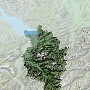
Relief map of the United Kingdom (with border and mask). This image was compiled from data acquired by landsat 5 & 7 satellites combined with elevation data
Universal Images Group (UIG) manages distribution for many leading specialist agencies worldwide
Media ID 9618985
© Planet Observer/UIG
Belfast Bristol British Isles Coastline Edinburgh Glasgow Great Britain Island Manchester North Sea Northern Ireland Relief Map Scotland Shore United Kingdom Wales Satellite View
A4 (29.7 x 21cm) Poster Print
Discover the intricacies of the United Kingdom's geography with our striking, large-format poster print from Media Storehouse. This captivating relief map, sourced from Universal Images Group (UIG), showcases the borders and unique topography of the UK in stunning detail. Compiled using data from Landsat 5 & 7 satellites and elevation data, this beautifully detailed poster is an essential addition to any home or office space, inspiring awe and intrigue in all who see it.
Premium quality poster prints are printed on luxurious semi-gloss satin 270 gsm paper. Our meticulously crafted poster prints offer an affordable option for decorating any space, making them ideal for living rooms, bedrooms, offices and beyond. To ensure your poster arrives in good condition, we roll and send them in strong mailing tubes.
Poster prints are budget friendly enlarged prints in standard poster paper sizes (A0, A1, A2, A3 etc). Whilst poster paper is sometimes thinner and less durable than our other paper types, they are still ok for framing and should last many years. Our Archival Quality Photo Prints and Fine Art Paper Prints are printed on higher quality paper and the choice of which largely depends on your budget.
Estimated Product Size is 21.6cm x 30.3cm (8.5" x 11.9")
These are individually made so all sizes are approximate
Artwork printed orientated as per the preview above, with landscape (horizontal) or portrait (vertical) orientation to match the source image.
EDITORS COMMENTS
This print showcases a detailed relief map of the United Kingdom, complete with borders and a mask. Compiled from data acquired by landsat 5 & 7 satellites combined with elevation data, this image offers an incredibly accurate representation of the British Isles' topography. From the bustling cities of Glasgow, Manchester, and London to the serene landscapes of Wales and Scotland, every corner is beautifully depicted. The photograph captures the diverse geography that makes up this island nation. The rugged coastlines along the North Sea and Irish Sea are highlighted, showcasing both its stunning beauty and strategic importance. The vast expanse of water surrounding England, Scotland, Wales, and Northern Ireland reminds us of their shared maritime heritage. With no people in sight, this aerial view allows us to appreciate the physical geography that shapes these lands. From rolling hills to towering mountains like Ben Nevis in Scotland or Snowdonia in Wales - each region has its own unique charm. Cartography enthusiasts will be enthralled by this color image as it provides an opportunity for exploration without leaving home. Whether you're studying Europe's physical features or simply admiring Britain's natural wonders from above – this print offers endless possibilities for discovery
MADE IN AUSTRALIA
Safe Shipping with 30 Day Money Back Guarantee
FREE PERSONALISATION*
We are proud to offer a range of customisation features including Personalised Captions, Color Filters and Picture Zoom Tools
SECURE PAYMENTS
We happily accept a wide range of payment options so you can pay for the things you need in the way that is most convenient for you
* Options may vary by product and licensing agreement. Zoomed Pictures can be adjusted in the Cart.