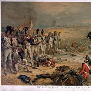
Poster Print > Universal Images Group (UIG) > Universal Images Group > Satellite and Aerial > Planet Observer 6
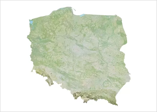
Poster Print : Poland, Relief Map


![]()
Poster Prints from Universal Images Group (UIG)
Poland, Relief Map
Relief map of Poland. This map was processed from elevation data
Universal Images Group (UIG) manages distribution for many leading specialist agencies worldwide
Media ID 9618383
© Planet Observer
Alsace Bas Rhin Geographical Border Relief Map Satellite View
A4 (29.7 x 21cm) Poster Print
Discover the intricacies of Poland's geography with our stunning Relief Map Print from Media Storehouse, in partnership with Universal Images Group (UIG). This captivating poster, featuring a relief representation of Poland's terrain, offers a unique and visually engaging perspective of the country's diverse topography. The high-quality print brings out the intricate details of the landscape, making it an excellent addition to any room or office space. Explore the beauty of Poland in a new light with our Relief Map Print.
Premium quality poster prints are printed on luxurious semi-gloss satin 270 gsm paper. Our meticulously crafted poster prints offer an affordable option for decorating any space, making them ideal for living rooms, bedrooms, offices and beyond. To ensure your poster arrives in good condition, we roll and send them in strong mailing tubes.
Poster prints are budget friendly enlarged prints in standard poster paper sizes (A0, A1, A2, A3 etc). Whilst poster paper is sometimes thinner and less durable than our other paper types, they are still ok for framing and should last many years. Our Archival Quality Photo Prints and Fine Art Paper Prints are printed on higher quality paper and the choice of which largely depends on your budget.
Estimated Product Size is 30.3cm x 21.6cm (11.9" x 8.5")
These are individually made so all sizes are approximate
Artwork printed orientated as per the preview above, with landscape (horizontal) or portrait (vertical) orientation to match the source image.
EDITORS COMMENTS
This stunning print showcases the intricate relief map of Poland, capturing its diverse topography and physical geography in remarkable detail. Processed from elevation data, this map offers a unique perspective on the country's landscape. From the towering peaks of the Tatra Mountains to the gentle rolling hills and vast plains, every contour is beautifully depicted. The vibrant colors used in this image bring out the various geographical features, allowing viewers to appreciate Poland's natural beauty at a glance. With no people present in the frame, one can fully immerse themselves in this cartographic creation. Shot from a vertical angle with a satellite view, this photograph provides an aerial-like perspective that adds depth and dimension to Poland's relief map. The geographical borders are clearly defined, highlighting not only Poland but also neighboring regions such as Alsace in France. Displayed outdoors against a backdrop of Bas Rhin's picturesque scenery, this print captures both artistry and scientific accuracy. It serves as an educational tool for those interested in studying or understanding Poland's terrain while simultaneously appealing to photography enthusiasts who appreciate visually striking compositions
MADE IN AUSTRALIA
Safe Shipping with 30 Day Money Back Guarantee
FREE PERSONALISATION*
We are proud to offer a range of customisation features including Personalised Captions, Color Filters and Picture Zoom Tools
SECURE PAYMENTS
We happily accept a wide range of payment options so you can pay for the things you need in the way that is most convenient for you
* Options may vary by product and licensing agreement. Zoomed Pictures can be adjusted in the Cart.