Home > Science > Space Exploration > Satellite Imagery
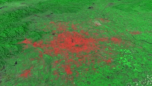
Beijing, China, 2010, satellite image
![]()

Wall Art and Photo Gifts from Science Photo Library
Beijing, China, 2010, satellite image
Beijing 2010. Satellite image showing the extent of the city of Beijing, China, in 2010. Beijing is one of the oldest cities in the world. Over the last 30 years its explosive growth has made it the most densely populated in the world. In 1972, Beijings population was about 7.9 million. By 2010 this had swelled to more than 12 million, fuelled by the success of economic reforms beginning in the 1970s. Imaged by the Thematic Mapper instrument onboard NASAs Landsat 5 satellite, on 8th August 2010
Science Photo Library features Science and Medical images including photos and illustrations
Media ID 9225993
© NASA/SCIENCE PHOTO LIBRARY
Beijing Cartography China Chinese City Country Coverage Dense Densely Populated Development Earth Observation Earth Science Expanded Expanding Expansion From Space Land Land Use Landsat 5 Physical Geography Satellite Satellite Image Urban 8 August Expanse Peking Sprawl
EDITORS COMMENTS
This print showcases the remarkable growth and development of Beijing, China, in 2010. Being one of the oldest cities in the world, Beijing has witnessed an explosive expansion over the last three decades, resulting in it becoming the most densely populated city on Earth. In just a span of 38 years, from 1972 to 2010, its population soared from approximately 7.9 million to over 12 million inhabitants. Captured by NASA's Landsat 5 satellite equipped with the Thematic Mapper instrument on August 8th, this satellite image reveals the vast expanse covered by Beijing's urban sprawl. The historical significance of this ancient Asian city is juxtaposed against its modern-day transformation into a bustling metropolis. The success of economic reforms initiated in the early 1970s played a pivotal role in fueling Beijing's rapid expansion. This print not only highlights China's impressive developmental journey but also sheds light on important aspects such as land use patterns and physical geography. As we gaze upon this awe-inspiring image taken from space, we are reminded of how human civilization continues to shape our planet and redefine our understanding of urban landscapes. It serves as a testament to both mankind's ability to adapt and thrive within their environment while raising questions about sustainability and managing exponential growth in an ever-changing world.
MADE IN AUSTRALIA
Safe Shipping with 30 Day Money Back Guarantee
FREE PERSONALISATION*
We are proud to offer a range of customisation features including Personalised Captions, Color Filters and Picture Zoom Tools
SECURE PAYMENTS
We happily accept a wide range of payment options so you can pay for the things you need in the way that is most convenient for you
* Options may vary by product and licensing agreement. Zoomed Pictures can be adjusted in the Cart.


