North-western Africa, satellite image C013 / 5160
![]()

Wall Art and Photo Gifts from Science Photo Library
North-western Africa, satellite image C013 / 5160
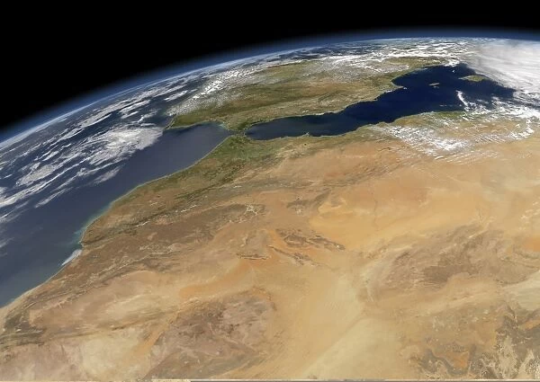
North-western Africa, satellite image. North is at top. This north-western portion of Africa, over a thousand kilometres across, includes Morocco (left) and northern parts of Algeria. The terrain is dominated by the Sahara Desert, with vegetation restricted to coastal areas. The Straits of Gibraltar (upper left) separate Africa from Europes Iberian Peninsula (top centre), and the western Mediterranean (upper right) from the North Atlantic (far left). Image data obtained on 31 March 2008, by the Moderate-resolution Imaging Spectroradiometer (MODIS) instrument on NASAs Aqua satellite, part of the Earth Observing System (EOS)
Science Photo Library features Science and Medical images including photos and illustrations
Media ID 9195893
© NASA/SCIENCE PHOTO LIBRARY
2008 Africa African Algeria Algerian Aqua Arid Atlantic Coast Barren Cloud Clouds Coast Curved Horizon Desert Dessicated Earth Observation Earth Observing System From Space Iberian Peninsula Land Mediterranean Sea Modis Moroccan Morocco Natural Colour North North Africa North Atlantic North West Northern Optical Physical Geography Planetary Limb Portugal Portuguese Sahara Saharan Sand Sandy Satellite Satellite Image Spain Spanish Visible West Western Coastal Vegetation Iberia
EDITORS COMMENTS
This stunning satellite image captures the vast expanse of north-western Africa, stretching over a thousand kilometers across. The photograph, taken on March 31,2008, by NASA's Aqua satellite using the Moderate-resolution Imaging Spectroradiometer (MODIS) instrument, showcases the remarkable geography and natural features of this region. At first glance, one cannot miss the dominance of the Sahara Desert that blankets most of the terrain. The arid and barren landscape is only interrupted by pockets of coastal vegetation along the western coastlines. To the left lies Morocco with its visible coastline while northern parts of Algeria occupy much of the center. The Straits of Gibraltar can be seen in the upper left corner separating Africa from Europe's Iberian Peninsula at top center. Meanwhile, to its right lies a beautiful contrast between the western Mediterranean and North Atlantic waters. The image reveals intricate details such as cloud formations scattered throughout this vast desert region. The curved horizon adds depth to this breathtaking view from space. This print serves as a reminder not only of Earth's diverse physical geography but also highlights our planet's delicate balance between land and sea. It is an awe-inspiring testament to nature's beauty captured through advanced optical technology provided by NASAs Aqua satellite and MODIS instrument as part of their Earth Observing System (EOS).
MADE IN AUSTRALIA
Safe Shipping with 30 Day Money Back Guarantee
FREE PERSONALISATION*
We are proud to offer a range of customisation features including Personalised Captions, Color Filters and Picture Zoom Tools
SECURE PAYMENTS
We happily accept a wide range of payment options so you can pay for the things you need in the way that is most convenient for you
* Options may vary by product and licensing agreement. Zoomed Pictures can be adjusted in the Cart.

