Home > Stocktrek Images > Space
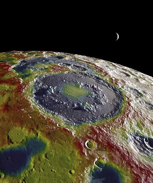
A free-air gravity map of the Moons southern latitudes
![]()

Wall Art and Photo Gifts from Stocktrek
A free-air gravity map of the Moons southern latitudes
This still image features a free-air gravity map of the Moons southern latitudes developed from data returned by the Gravity Recovery and Interior Laboratory (GRAIL) mission.
A
The free-air gravity map shows deviations from the mean gravity that a cueball Moon would have. The deviations are measured in milliGals, a unit of acceleration. On the map, purple is at the low end of the range, at around -400 mGals, and red is at the high end near +400 mGals. Yellow denotes the mean.
A
The map shown here extends from the south pole of the Moon up to 50A'S and reveals the gravity for that region in even finer detail than the global gravity maps published previously. The image illustrates the very good correlation between the gravity map and topographic features such as peaks and craters, as well as the mass concentration lying beneath the large Schrodinger basin in the center of the frame. The terrain in the image is based on Lunar Reconnaissance Orbiter (LRO) altimeter and camera data
Stocktrek Images specializes in Astronomy, Dinosaurs, Medical, Military Forces, Ocean Life, & Sci-Fi
Media ID 13059575
© Stocktrek Images
Black Background Blue Bright Color Cartography Climate Colorful Crescent Moon Geography Gravitational Field Gravity Horizon Land Lithosphere Meteorology Multi Colored Overhead View Physical Geography Surface Terrain Topography Weather Yellow Evolution Grail View From Space
EDITORS COMMENTS
This print showcases a free-air gravity map of the Moon's southern latitudes, meticulously developed from data collected by the Gravity Recovery and Interior Laboratory (GRAIL) mission. The map vividly displays deviations in milliGals, measuring acceleration, from what a perfectly smooth Moon would possess. With purple representing the lower end at approximately -400 mGals and red indicating the higher end near +400 mGals, yellow signifies the mean gravity level. Covering an extensive area extending from the south pole up to 50°S, this detailed map offers unprecedented insight into the region's gravitational forces compared to previously published global maps. Notably, it reveals an astonishing correlation between topographic features such as peaks and craters with variations in gravity. Moreover, it exposes a mass concentration hidden beneath the expansive Schrodinger basin positioned prominently at the center of this awe-inspiring frame. The terrain depicted in this image is based on precise Lunar Reconnaissance Orbiter (LRO) altimeter and camera data—ensuring accuracy beyond reproach. This remarkable visual representation serves as a testament to humanity's relentless pursuit of knowledge about our celestial neighbor while showcasing both scientific ingenuity and artistic brilliance simultaneously.
MADE IN AUSTRALIA
Safe Shipping with 30 Day Money Back Guarantee
FREE PERSONALISATION*
We are proud to offer a range of customisation features including Personalised Captions, Color Filters and Picture Zoom Tools
SECURE PAYMENTS
We happily accept a wide range of payment options so you can pay for the things you need in the way that is most convenient for you
* Options may vary by product and licensing agreement. Zoomed Pictures can be adjusted in the Cart.

