Home > Science > Space Exploration > Planets > Earth
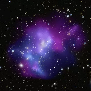
View over Greenland and the Arctic Ocean

![]()
Wall Art and Photo Gifts from Stocktrek
View over Greenland and the Arctic Ocean
Operation Ice Bridge is a six-year campaign of annual flights to each of Earths polar regions. The first flights in March and April carried researchers over Greenland and the Arctic Ocean. The Ice Bridge flights will help scientists maintain the record of changes to sea ice and ice sheets that have been collected since 2003 by ICESat. The flights will lack the continent-wide coverage that can be achieved by satellite, so researchers carefully select key target locations. But the flights will also turn up new information not possible from orbit, such as the shape of the terrain below the ice
Stocktrek Images specializes in Astronomy, Dinosaurs, Medical, Military Forces, Ocean Life, & Sci-Fi
Media ID 13058347
© Stocktrek Images
Archipelago Arctic Arctic Circle Arctic Ocean Canada Climate Change Continent Earth Earth Science Geography Glacier Global Warming Greenland Ice Sheets Ice Shelf Island Northern Hemisphere Planet Polar Climate Polar Regions Round Semicircle Snow Sphere Winter Cryosphere View From Space
FEATURES IN THESE COLLECTIONS
> Arts
> Contemporary art
> Photography
> Digital art
> North America
> Canada
> Related Images
> North America
> Greenland
> Related Images
> Science
> Scientists
> Science
> Space Exploration
> Planets
> Earth
EDITORS COMMENTS
This print showcases a breathtaking view over Greenland and the Arctic Ocean, captured during Operation Ice Bridge. This ambitious six-year campaign involves annual flights to both of Earth's polar regions, with the aim of aiding scientists in maintaining a comprehensive record of changes to sea ice and ice sheets. Since 2003, data collected by ICESat has been instrumental in understanding these transformations, but the limited coverage provided by satellites necessitates careful selection of target locations for the flights. While satellite imagery offers continent-wide perspectives, the Ice Bridge flights offer unique insights not attainable from orbit. One such advantage is revealing the intricate shape and topography beneath vast expanses of ice. This digitally generated image portrays our planet as a spherical entity floating amidst space; devoid of human presence yet brimming with natural wonders. The photograph encapsulates an array of elements: glaciers cascading down rugged terrain, snow-covered landscapes stretching into infinity, and icy shelves jutting out into frigid waters. The Canadian archipelago punctuates this mesmerizing scene while reminding us that even seemingly remote places are interconnected within Earth's delicate ecosystem. As we gaze upon this awe-inspiring vista, it serves as a stark reminder that our planet is undergoing significant climate change due to global warming. The cryosphere – encompassing all frozen forms on Earth – bears witness to these alterations in its very essence. Through Stocktrek Images' lens, this single object captures not just an image but also humanity's quest for knowledge about our world's polar regions and their crucial role in shaping our climate system.
MADE IN AUSTRALIA
Safe Shipping with 30 Day Money Back Guarantee
FREE PERSONALISATION*
We are proud to offer a range of customisation features including Personalised Captions, Color Filters and Picture Zoom Tools
SECURE PAYMENTS
We happily accept a wide range of payment options so you can pay for the things you need in the way that is most convenient for you
* Options may vary by product and licensing agreement. Zoomed Pictures can be adjusted in the Cart.