Home > Arts > Artists > O > Abraham Ortelius
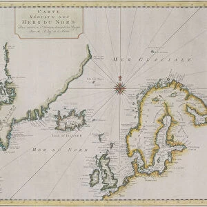
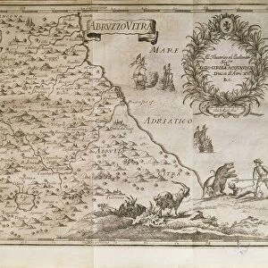
Map of Northern Europe, from Theatrum Orbis Terrarum by Abraham Ortelius, 1528-1598, 1570

![]()
Wall Art and Photo Gifts from Universal Images Group (UIG)
Map of Northern Europe, from Theatrum Orbis Terrarum by Abraham Ortelius, 1528-1598, 1570
Cartography, 16th century. Map of Northern Europe, from Theatrum Orbis Terrarum by Abraham Ortelius (1528-1598), Antwerp, 1570
Universal Images Group (UIG) manages distribution for many leading specialist agencies worldwide
Media ID 9505609
© DEA / A. DAGLI ORTI
1570 16th Century Abraham Ortelius Aerial View Coastline Denmark Finland Greenland Guidance Iceland Island Journey Latin Script Nautical Vessel Navigational Equipment Norway Peninsula River Sailing Ship Scandinavia Ship Sweden Text Theatrum Orbis Terrarum Non Urban Scene
FEATURES IN THESE COLLECTIONS
> Aerial Photography
> Denmark
> Aerial Photography
> Finland
> Aerial Photography
> Iceland
> Arts
> Art Movements
> Landscapes
> Arts
> Artists
> O
> Abraham Ortelius
> Arts
> Contemporary art
> Landscapes
> Sculptures
> Arts
> Contemporary art
> Sculpture
> Landscape paintings
> Maps and Charts
> Abraham Ortelius
> Universal Images Group (UIG)
> Art
> Painting, Sculpture & Prints
> Cartography
EDITORS COMMENTS
This print showcases a remarkable piece of cartography from the 16th century. The image features a Map of Northern Europe, meticulously crafted by Abraham Ortelius (1528-1598) and published in Antwerp in 1570 as part of his renowned work, Theatrum Orbis Terrarum. The map provides an intricate depiction of the topography and physical geography of the region, encompassing countries such as Finland, Sweden, Denmark, Norway, Iceland, and even Greenland. Its detailed illustrations highlight rivers snaking through lush landscapes while coastlines gracefully meet with vast bodies of water. A sailing ship gracefully glides across the sea on its journey through these northern European waters. This aerial view offers a glimpse into how navigational equipment was utilized during this era for safe passage along treacherous coastlines. The Latin script accompanying the map serves as both guidance and historical documentation. It transports us back to a time when exploration and discovery were at their peak. Through this artful representation captured in this print by Universal Images Group (UIG), we are reminded of the rich history that lies within maps like these - not just as tools for navigation but also as works of art that encapsulate our understanding and perception of the world around us.
MADE IN AUSTRALIA
Safe Shipping with 30 Day Money Back Guarantee
FREE PERSONALISATION*
We are proud to offer a range of customisation features including Personalised Captions, Color Filters and Picture Zoom Tools
SECURE PAYMENTS
We happily accept a wide range of payment options so you can pay for the things you need in the way that is most convenient for you
* Options may vary by product and licensing agreement. Zoomed Pictures can be adjusted in the Cart.