Home > Europe > France > Canton > Landes
1801 Cary Map Of Turkey Iraq Armenia And Sryia

![]()
Wall Art and Photo Gifts from Universal Images Group (UIG)
1801 Cary Map Of Turkey Iraq Armenia And Sryia
1801, Cary Map of Turkey, Iraq, Armenia and Sryia, John Cary, 1754 - 1835, English cartographer
Universal Images Group (UIG) manages distribution for many leading specialist agencies worldwide
Media ID 38548353
© Artokoloro Quint Lox Limited
1754 – 1835 1801 English Cartographer Iraq John Cary Antique Map Latitude Longitude Mappa Mundi Old Antique Plan Old Antique View Ols Antique Map Rare Old Maps Topo
FEATURES IN THESE COLLECTIONS
> Asia
> Armenia
> Related Images
> Asia
> Iraq
> Related Images
> Asia
> Turkey
> Related Images
> Europe
> Armenia
> Related Images
> Europe
> France
> Canton
> Landes
> Historic
> Space exploration
> Universal Images Group (UIG)
> History
> Historical Maps
EDITORS COMMENTS
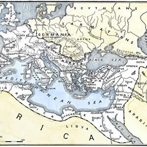
Step back in time with this stunning 1801 map of Turkey, Iraq, Armenia, and Syria by renowned English cartographer John Cary. This beautifully rendered print showcases the intricate topography and geography of the region during a pivotal moment in history. The level of detail is remarkable, with meticulous illustrations of mountains, rivers, cities, and trade routes.
Cary's work was highly regarded for its accuracy and beauty during his lifetime (1754-1835), earning him the title 'one of the most important cartographers of his generation'. This particular map is a testament to his skill as an artist and cartographer.
The map provides a fascinating glimpse into the region's past, highlighting ancient trade routes that connected distant lands. It also offers insight into the cultural exchange between civilizations that took place along these paths.
This vintage print would make a unique addition to any collection or room decor. Its aged appearance adds to its charm, evoking feelings of nostalgia and wonder at the passage of time. Whether you're an historian, geographer or simply someone who appreciates beautiful artistry, this map is sure to captivate.
MADE IN AUSTRALIA
Safe Shipping with 30 Day Money Back Guarantee
FREE PERSONALISATION*
We are proud to offer a range of customisation features including Personalised Captions, Color Filters and Picture Zoom Tools
SECURE PAYMENTS
We happily accept a wide range of payment options so you can pay for the things you need in the way that is most convenient for you
* Options may vary by product and licensing agreement. Zoomed Pictures can be adjusted in the Cart.