Home > Animals > Mammals > Soricidae > Niger
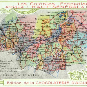
1813 Pinkerton Map Of Western Africa Niger Valley

![]()
Wall Art and Photo Gifts from Universal Images Group (UIG)
1813 Pinkerton Map Of Western Africa Niger Valley
1813, Pinkerton Map of Western Africa, Niger Valley, Mountains of Kong, John Pinkerton, 1758 - 1826, Scottish antiquarian, cartographer, UK
Universal Images Group (UIG) manages distribution for many leading specialist agencies worldwide
Media ID 38548347
© Artokoloro Quint Lox Limited
1758 – 1826 1813 Cartographer John Pinkerton Scottish Antiquarian Antique Map Latitude Longitude Mappa Mundi Old Antique Plan Old Antique View Ols Antique Map Rare Old Maps Topo
FEATURES IN THESE COLLECTIONS
> Africa
> Niger
> Related Images
> Animals
> Mammals
> Soricidae
> Niger
> Europe
> France
> Canton
> Landes
> Europe
> United Kingdom
> Maps
> Europe
> United Kingdom
> Scotland
> Maps
> Europe
> United Kingdom
> Scotland
> Related Images
> Historic
> Space exploration
> Maps and Charts
> Early Maps
> Universal Images Group (UIG)
> History
> Historical Maps
EDITORS COMMENTS
Step back in time to the early 19th century with this stunning print of John Pinkerton's 1813 map of Western Africa, specifically highlighting the Niger Valley and the mythical Mountains of Kong. This beautifully rendered illustration is a testament to Pinkerton's expertise as a Scottish antiquarian and cartographer. The intricate details on this vintage map showcase his meticulous attention to topography, geography, and navigation.
The Niger Valley, a region rich in natural resources and cultural heritage, is depicted with remarkable accuracy considering the limited knowledge of the area at that time. The Mountains of Kong, however, remain shrouded in mystery - their existence was later disputed by explorers and cartographers.
This historic map not only provides insight into Pinkerton's work but also serves as a window into the world's understanding of geography during that era. It showcases the evolution of cartography and highlights the importance of exploration and discovery in shaping our understanding of our planet.
Printed on high-quality paper, this vintage map makes for a unique piece of art perfect for any history enthusiast or collector. Its aged appearance adds an air of nostalgia and character to any room or office space.
MADE IN AUSTRALIA
Safe Shipping with 30 Day Money Back Guarantee
FREE PERSONALISATION*
We are proud to offer a range of customisation features including Personalised Captions, Color Filters and Picture Zoom Tools
SECURE PAYMENTS
We happily accept a wide range of payment options so you can pay for the things you need in the way that is most convenient for you
* Options may vary by product and licensing agreement. Zoomed Pictures can be adjusted in the Cart.