Home > Europe > France > Canton > Landes
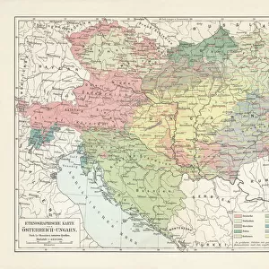
1862 Stieler Map Of Poland And Hungary Topography

![]()
Wall Art and Photo Gifts from Universal Images Group (UIG)
1862 Stieler Map Of Poland And Hungary Topography
1862, Stieler Map of Poland and Hungary
Universal Images Group (UIG) manages distribution for many leading specialist agencies worldwide
Media ID 38551588
© Artokoloro Quint Lox Limited
1862 Antique Map Latitude Longitude Mappa Mundi Old Antique Plan Old Antique View Ols Antique Map Rare Old Maps Topo
FEATURES IN THESE COLLECTIONS
> Europe
> France
> Canton
> Landes
> Europe
> Hungary
> Related Images
> Europe
> Poland
> Related Images
> Historic
> Space exploration
> Maps and Charts
> Early Maps
> Maps and Charts
> Related Images
> Universal Images Group (UIG)
> History
> Historical Maps
EDITORS COMMENTS
Step back in time to the mid-19th century with this stunning print of the 1862 Stieler Map of Poland and Hungary Topography. This beautifully rendered illustration is a testament to the cartographic skills of its creator, Adolf Stieler, who was renowned for his meticulous attention to detail and commitment to accuracy.
This vintage map showcases the region's topography with remarkable precision, featuring intricate details such as mountains, rivers, forests, and cities. The map's borders are adorned with decorative elements, adding an air of elegance and sophistication to this already impressive piece.
The 1862 Stieler Map of Poland and Hungary Topography is not only a fascinating historical artifact but also a valuable resource for anyone interested in geography, cartography, or travel. It offers a unique glimpse into the past, providing insight into how our understanding of the world has evolved over time.
Printed on high-quality paper and measuring [insert dimensions], this beautiful reproduction is sure to be a treasured addition to any collection or room decor. Its aged appearance adds character and charm, making it a conversation starter that will spark curiosity and fascination in all who lay eyes on it.
MADE IN AUSTRALIA
Safe Shipping with 30 Day Money Back Guarantee
FREE PERSONALISATION*
We are proud to offer a range of customisation features including Personalised Captions, Color Filters and Picture Zoom Tools
SECURE PAYMENTS
We happily accept a wide range of payment options so you can pay for the things you need in the way that is most convenient for you
* Options may vary by product and licensing agreement. Zoomed Pictures can be adjusted in the Cart.