Canvas Print > Fine Art Storehouse > Map
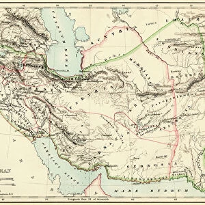
Canvas Print : Map of Western Europe 1883


![]()
Canvas Prints from Fine Art Storehouse
Map of Western Europe 1883
Warrens Common School Geography
Unleash your creativity and transform your space into a visual masterpiece!
THEPALMER
Media ID 13669373
© This content is subject to copyright
20"x16" (51x41cm) Canvas Print
Step back in time with our exquisite Map of Western Europe 1883 Canvas Print from ThePalmer at Media Storehouse. This captivating piece, inspired by Warrens Common School Geography, transports you to an era of exploration and discovery. The intricate details of this vintage map are brought to life with our premium canvas printing process, ensuring a stunning and vibrant display. Add a touch of history and character to your home or office decor with this unique and timeless addition to your collection.
Delivered stretched and ready to hang our premium quality canvas prints are made from a polyester/cotton blend canvas and stretched over a 1.25" (32mm) kiln dried knot free wood stretcher bar. Packaged in a plastic bag and secured to a cardboard insert for safe transit.
Canvas Prints add colour, depth and texture to any space. Professionally Stretched Canvas over a hidden Wooden Box Frame and Ready to Hang
Estimated Product Size is 40.6cm x 50.8cm (16" x 20")
These are individually made so all sizes are approximate
Artwork printed orientated as per the preview above, with portrait (vertical) orientation to match the source image.
FEATURES IN THESE COLLECTIONS
> Fine Art Storehouse
> The Magical World of Illustration
> Palmer Illustrated Collection
> Fine Art Storehouse
> Map
> Historical Maps
> Fine Art Storehouse
> Map
> USA Maps
EDITORS COMMENTS
In this print titled "Map of Western Europe 1883" we are transported back in time to an era when cartography was a true art form. The intricate details and delicate engravings on the old paper take us on a journey through the diverse landscapes of France, Portugal, Spain, and beyond. The map's vertical orientation allows us to fully appreciate the vastness of these European territories as they stretch from one corner to another. Each country is meticulously outlined with precision, showcasing their borders and geographical features. It is fascinating to observe how different regions were interconnected during this period. As our eyes wander across the map, we cannot help but notice that even across the Atlantic Ocean lies a small depiction of the United States - a reminder of historical connections between continents. This inclusion adds an extra layer of intrigue and invites contemplation about global relationships at that time. "The Map of Western Europe 1883" exudes an antique charm that transports us into classrooms where students once studied geography using similar illustrations. Its engraved image captures not only physical geography but also serves as a testament to human curiosity about our world's wonders. This stunning piece by THEPALMER showcases both artistic skill and historical significance. Whether you are an enthusiast for cartography or simply captivated by vintage aesthetics, this print will undoubtedly add depth and character to any space it graces within your home or office décor collection.
MADE IN AUSTRALIA
Safe Shipping with 30 Day Money Back Guarantee
FREE PERSONALISATION*
We are proud to offer a range of customisation features including Personalised Captions, Color Filters and Picture Zoom Tools
SECURE PAYMENTS
We happily accept a wide range of payment options so you can pay for the things you need in the way that is most convenient for you
* Options may vary by product and licensing agreement. Zoomed Pictures can be adjusted in the Cart.