Jigsaw Puzzle > Fine Art Storehouse > Map
Jigsaw Puzzle : Map of Western Europe 1883


![]()
Jigsaw Puzzles from Fine Art Storehouse
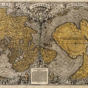
Map of Western Europe 1883
Warrens Common School Geography
Unleash your creativity and transform your space into a visual masterpiece!
THEPALMER
Media ID 13669373
© This content is subject to copyright
Jigsaw Puzzle (500 Pieces)
Discover the intrigue of the past with our exquisite Map of Western Europe 1883 jigsaw puzzle from ThePalmer at Media Storehouse. This captivating puzzle, sourced from the Fine Art Storehouse and Warrens Common School Geography collection, invites you on a journey back in time. With intricate details and vibrant colors, this puzzle is not just a pastime, but an opportunity to learn and explore the historical geography of Western Europe in 1883. Engage your mind and unleash your creativity as you piece together this beautiful puzzle, making it a perfect activity for families, friends, or individuals seeking a challenging and rewarding experience.
500 piece puzzles are custom made in Australia and hand-finished on 100% recycled 1.6mm thick laminated puzzle boards. There is a level of repetition in jigsaw shapes with each matching piece away from its pair. The completed puzzle measures 40x51cm and is delivered packaged in an attractive presentation box specially designed to fit most mail slots with a unique magnetic lid
Jigsaw Puzzles are an ideal gift for any occasion
Estimated Product Size is 40.3cm x 50.7cm (15.9" x 20")
These are individually made so all sizes are approximate
Artwork printed orientated as per the preview above, with landscape (horizontal) or portrait (vertical) orientation to match the source image.
FEATURES IN THESE COLLECTIONS
> Fine Art Storehouse
> The Magical World of Illustration
> Palmer Illustrated Collection
> Fine Art Storehouse
> Map
> Historical Maps
> Fine Art Storehouse
> Map
> USA Maps
EDITORS COMMENTS
In this print titled "Map of Western Europe 1883" we are transported back in time to an era when cartography was a true art form. The intricate details and delicate engravings on the old paper take us on a journey through the diverse landscapes of France, Portugal, Spain, and beyond. The map's vertical orientation allows us to fully appreciate the vastness of these European territories as they stretch from one corner to another. Each country is meticulously outlined with precision, showcasing their borders and geographical features. It is fascinating to observe how different regions were interconnected during this period. As our eyes wander across the map, we cannot help but notice that even across the Atlantic Ocean lies a small depiction of the United States - a reminder of historical connections between continents. This inclusion adds an extra layer of intrigue and invites contemplation about global relationships at that time. "The Map of Western Europe 1883" exudes an antique charm that transports us into classrooms where students once studied geography using similar illustrations. Its engraved image captures not only physical geography but also serves as a testament to human curiosity about our world's wonders. This stunning piece by THEPALMER showcases both artistic skill and historical significance. Whether you are an enthusiast for cartography or simply captivated by vintage aesthetics, this print will undoubtedly add depth and character to any space it graces within your home or office décor collection.
MADE IN AUSTRALIA
Safe Shipping with 30 Day Money Back Guarantee
FREE PERSONALISATION*
We are proud to offer a range of customisation features including Personalised Captions, Color Filters and Picture Zoom Tools
SECURE PAYMENTS
We happily accept a wide range of payment options so you can pay for the things you need in the way that is most convenient for you
* Options may vary by product and licensing agreement. Zoomed Pictures can be adjusted in the Cart.