Canvas Print > Arts > Artists > M > Juan Martinez
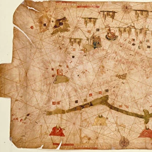
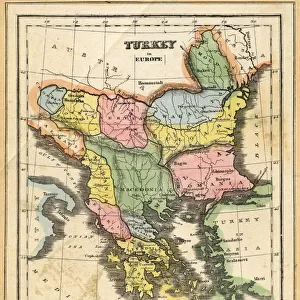
Canvas Print : WORLD MAP, 1587. Map of the world by Juan Martinez from Atlas Portulano, Madrid, 1587


![]()
Canvas Prints from Granger
WORLD MAP, 1587. Map of the world by Juan Martinez from Atlas Portulano, Madrid, 1587
WORLD MAP, 1587.
Map of the world by Juan Martinez from Atlas Portulano, Madrid, 1587
Granger holds millions of images spanning more than 25,000 years of world history, from before the Stone Age to the dawn of the Space Age
Media ID 12321231
1587 Earth Eastern Geography Globe Hemisphere Juan Martinez Spanish Western World
20"x16" (51x41cm) Canvas Print
Step back in time with our exquisite Canvas Print of the 1587 World Map by Juan Martinez from Atlas Portulano. This intricately detailed masterpiece, sourced from Granger Art on Demand, offers a captivating glimpse into the cartography of the past. The vintage hues and textures of the canvas bring the historic map to life, making it a stunning addition to any room in your home or office. Transport yourself to a bygone era with this unique and captivating piece of art.
Delivered stretched and ready to hang our premium quality canvas prints are made from a polyester/cotton blend canvas and stretched over a 1.25" (32mm) kiln dried knot free wood stretcher bar. Packaged in a plastic bag and secured to a cardboard insert for safe transit.
Canvas Prints add colour, depth and texture to any space. Professionally Stretched Canvas over a hidden Wooden Box Frame and Ready to Hang
Estimated Product Size is 50.8cm x 40.6cm (20" x 16")
These are individually made so all sizes are approximate
Artwork printed orientated as per the preview above, with landscape (horizontal) orientation to match the source image.
FEATURES IN THESE COLLECTIONS
> Arts
> Art Movements
> Renaissance Art
> Arts
> Artists
> M
> Juan Martinez
> Maps and Charts
> Related Images
> Maps and Charts
> Spain
> Maps and Charts
> World
> Granger Art on Demand
> Maps
EDITORS COMMENTS
This print showcases the intricate "WORLD MAP, 1587" created by Juan Martinez for the Atlas Portulano in Madrid during the late Renaissance period. The map, a true testament to the artistry and scientific knowledge of its time, offers a glimpse into how people perceived and understood the world nearly five centuries ago. With its rich details and vibrant colors, this map takes us back to an era when exploration was at its peak. It presents both familiar territories and mysterious lands yet to be discovered, labeled as "terra incognita". As we examine it closely, we can't help but marvel at how different our understanding of geography is today. The map's significance lies not only in its depiction of continents and oceans but also in its portrayal of cultural connections between Eastern and Western civilizations. It serves as a reminder that even in the 16th century, there were extensive trade routes connecting distant corners of the globe. As we gaze upon this remarkable piece of history suspended on our walls, it sparks curiosity about those who came before us - their ambitions, their thirst for knowledge, and their relentless pursuit of discovery. This World Map from 1587 allows us to appreciate how far humanity has come while reminding us that there will always be more to explore beyond what meets the eye.
MADE IN AUSTRALIA
Safe Shipping with 30 Day Money Back Guarantee
FREE PERSONALISATION*
We are proud to offer a range of customisation features including Personalised Captions, Color Filters and Picture Zoom Tools
SECURE PAYMENTS
We happily accept a wide range of payment options so you can pay for the things you need in the way that is most convenient for you
* Options may vary by product and licensing agreement. Zoomed Pictures can be adjusted in the Cart.