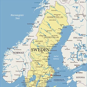
Canvas Print > Europe > Sweden > Maps
Canvas Print : Map of Prussia, c1872. Creator: Unknown


![]()
Canvas Prints from Heritage Images
Map of Prussia, c1872. Creator: Unknown
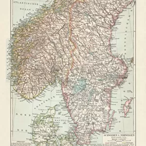
Map of Prussia, c1872. Showing the various regions including Holstein, Hanover, Westphalia, Lower Rhine, Lorraine, Nassau, Cassel, Saxony, Brandedburg, Silesia, Pomerania, West Prussia, East Prussia and Posen. From " The Franco-Prussian War: its causes, incidents and consequences", Volume I, by Captain H M Hozier. [William Mackenzie, London, 1872]
Heritage Images features heritage image collections
Media ID 19780443
© The Print Collector/Heritage Images
1870 1871 Baltic Sea Coastline Franco Prussian War H M Hozier Henry Montague Henry Montague Hozier Hozier Mackenzie North Sea Prussia Prussian Sir Henry Montagu Hozier Territorial Territory William Mackenzie Jutland
20"x16" (51x41cm) Canvas Print
"Step back in time with our vintage Map of Prussia Canvas Print from the Media Storehouse collection at Heritage Images. This captivating image, created around 1872, showcases the intricate details of Prussia during that era. Delve into the history of this fascinating region as you explore the various provinces, including Holstein, Hanover, Westphalia, Lower Rhine, Lorraine, Nassau, Cassel, Saxony, Brandenburg, Silesia, Pomerania, and West Prussia. Add this unique piece to your home decor and let the rich history of Prussia come alive in your living space."
Delivered stretched and ready to hang our premium quality canvas prints are made from a polyester/cotton blend canvas and stretched over a 1.25" (32mm) kiln dried knot free wood stretcher bar. Packaged in a plastic bag and secured to a cardboard insert for safe transit.
Canvas Prints add colour, depth and texture to any space. Professionally Stretched Canvas over a hidden Wooden Box Frame and Ready to Hang
Estimated Product Size is 50.8cm x 40.6cm (20" x 16")
These are individually made so all sizes are approximate
Artwork printed orientated as per the preview above, with landscape (horizontal) orientation to match the source image.
FEATURES IN THESE COLLECTIONS
> Europe
> Sweden
> Related Images
> Maps and Charts
> Related Images
EDITORS COMMENTS
This print showcases a detailed "Map of Prussia" from the year 1872, created by an unknown artist. The map provides a comprehensive view of the various regions within Prussia during that time period, including Holstein, Hanover, Westphalia, Lower Rhine, Lorraine, Nassau, Cassel, Saxony, Brandedburg, Silesia, Pomerania, West Prussia, East Prussia and Posen. It is sourced from Captain H M Hozier's book titled "The Franco-Prussian War: its causes incidents and consequences", Volume I. The map not only highlights the territorial boundaries but also emphasizes the coastal areas along Germany's coastline on both the North Sea and Baltic Sea. With vibrant colors and intricate details representing geographical features such as rivers and mountains; this 19th-century map offers a fascinating glimpse into Prussian history. As we delve into this historical artifact capturing a significant era in European history marked by conflicts like the Franco-Prussian War (1870-1871), it becomes evident how crucial maps were for understanding strategic locations during times of war. This particular print serves as a valuable resource for researchers studying territorial changes and geopolitical dynamics in Central Europe during that period. Preserved by The Print Collector under their vast collection encompassing diverse subjects beyond commercial use limitations; this remarkable piece allows us to appreciate Sir Henry Montagu Hozier's contribution to cartography through his publication with William Mackenzie in London back in
MADE IN AUSTRALIA
Safe Shipping with 30 Day Money Back Guarantee
FREE PERSONALISATION*
We are proud to offer a range of customisation features including Personalised Captions, Color Filters and Picture Zoom Tools
SECURE PAYMENTS
We happily accept a wide range of payment options so you can pay for the things you need in the way that is most convenient for you
* Options may vary by product and licensing agreement. Zoomed Pictures can be adjusted in the Cart.