Canvas Print > Historic > Ancient civilizations > Ancient Greece > Athens
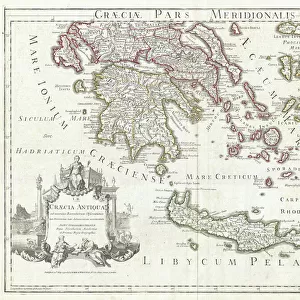
Canvas Print : 1784, Bocage Map of the City of Athens in Ancient Greece, topography, cartography


![]()
Canvas Prints from Liszt Collection
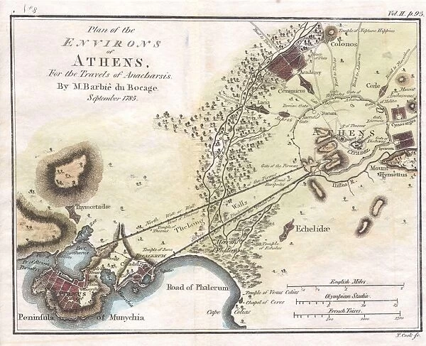
1784, Bocage Map of the City of Athens in Ancient Greece, topography, cartography
1784, Bocage Map of the City of Athens in Ancient Greece
Liszt Collection of nineteenth-century engravings and images to browse and enjoy
Media ID 14006840
© Artokoloro Quint Lox Limited
1784 Antique Map Latitude Longitude Mappa Mundi Old Antique Plan Old Antique View Ols Antique Map Rare Old Maps Topo
20"x16" (51x41cm) Canvas Print
Step back in time with our exquisite Canvas Print of the 1784 Bocage Map of the City of Athens from the renowned Liszt Collection. This captivating piece showcases the ancient Greek city in intricate detail, with topographical and cartographic accuracy that transports you back to the heart of ancient civilization. The rich, textured canvas brings out the intricacies of the map's lines and shading, while the high-quality print preserves the authenticity of the original. Add a touch of history and sophistication to your home or office with this stunning, one-of-a-kind artwork.
Delivered stretched and ready to hang our premium quality canvas prints are made from a polyester/cotton blend canvas and stretched over a 1.25" (32mm) kiln dried knot free wood stretcher bar. Packaged in a plastic bag and secured to a cardboard insert for safe transit.
Canvas Prints add colour, depth and texture to any space. Professionally Stretched Canvas over a hidden Wooden Box Frame and Ready to Hang
Estimated Product Size is 50.8cm x 40.6cm (20" x 16")
These are individually made so all sizes are approximate
Artwork printed orientated as per the preview above, with landscape (horizontal) orientation to match the source image.
FEATURES IN THESE COLLECTIONS
> Europe
> France
> Canton
> Landes
> Europe
> Greece
> Related Images
> Historic
> Ancient civilizations
> Ancient Greece
> Athens
> Historic
> Ancient civilizations
> Ancient Greece
> Greek history
> Historic
> Space exploration
> Maps and Charts
> Early Maps
EDITORS COMMENTS
This print showcases the exquisite 1784 Bocage Map of the City of Athens in Ancient Greece. A true masterpiece in topography and cartography, this vintage map offers a fascinating glimpse into the ancient world. With its intricate details and precise measurements, it serves as a valuable historical artifact that transports us back to a time long gone. The artistry behind this map is truly remarkable. Every contour, every street, and every landmark is meticulously illustrated with stunning accuracy. Its delicate lines form an intricate grid of latitude and longitude, allowing viewers to navigate through the city's rich history effortlessly. As we gaze upon this aged piece of art, we are reminded of the countless journeys and discoveries made by explorers who once relied on such maps for navigation. It evokes a sense of wonderment about our planet's past and ignites our curiosity about civilizations that thrived centuries ago. With its decorative appeal, this antique map adds a touch of elegance to any space it graces. Whether displayed in a study or framed on a wall, it becomes both an educational tool and an object d'art that sparks conversations about ancient cultures. The Liszt Collection has preserved this rare gem from history for all to admire—a testament to their dedication in safeguarding our collective heritage.
MADE IN AUSTRALIA
Safe Shipping with 30 Day Money Back Guarantee
FREE PERSONALISATION*
We are proud to offer a range of customisation features including Personalised Captions, Color Filters and Picture Zoom Tools
SECURE PAYMENTS
We happily accept a wide range of payment options so you can pay for the things you need in the way that is most convenient for you
* Options may vary by product and licensing agreement. Zoomed Pictures can be adjusted in the Cart.