Canvas Print > Europe > United Kingdom > Scotland > Maps
Canvas Print : 1855, Colton Map of Scotland, topography, cartography, geography, land, illustration


![]()
Canvas Prints from Liszt Collection
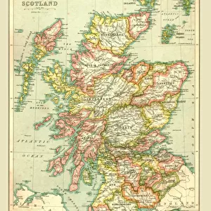
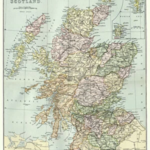
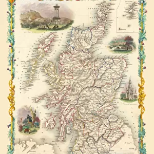
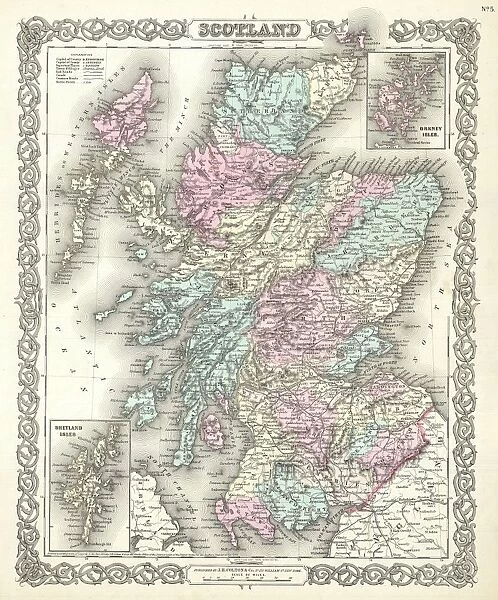
1855, Colton Map of Scotland, topography, cartography, geography, land, illustration
1855, Colton Map of Scotland
Liszt Collection of nineteenth-century engravings and images to browse and enjoy
Media ID 14007526
© Artokoloro Quint Lox Limited
1855 Antique Map Latitude Longitude Mappa Mundi Old Antique Plan Old Antique View Ols Antique Map Rare Old Maps Topo
20"x16" (51x41cm) Canvas Print
Discover the rich history and intricate details of Scotland with our stunning Canvas Print from Media Storehouse's collection. Featuring the 1855 Colton Map of Scotland from the renowned Liszt Collection, this piece showcases the topography, cartography, and geography of the land in exquisite detail. With its impressive illustration of Scotland during that era, this Canvas Print is not just a decorative addition to your space, but a conversation starter and a testament to the beauty and history of Scotland. Bring the past to life in your home or office today with Media Storehouse's Canvas Prints.
Delivered stretched and ready to hang our premium quality canvas prints are made from a polyester/cotton blend canvas and stretched over a 1.25" (32mm) kiln dried knot free wood stretcher bar. Packaged in a plastic bag and secured to a cardboard insert for safe transit.
Canvas Prints add colour, depth and texture to any space. Professionally Stretched Canvas over a hidden Wooden Box Frame and Ready to Hang
Estimated Product Size is 40.6cm x 50.8cm (16" x 20")
These are individually made so all sizes are approximate
Artwork printed orientated as per the preview above, with portrait (vertical) orientation to match the source image.
FEATURES IN THESE COLLECTIONS
> Europe
> France
> Canton
> Landes
> Europe
> United Kingdom
> Scotland
> Maps
> Europe
> United Kingdom
> Scotland
> Posters
> Europe
> United Kingdom
> Scotland
> Related Images
> Historic
> Space exploration
> Maps and Charts
> Early Maps
> Maps and Charts
> Related Images
> Maps and Charts
> World
EDITORS COMMENTS
This print showcases the remarkable 1855 Colton Map of Scotland, a true masterpiece in topography, cartography, and geography. The intricate details and precision of this vintage illustration transport us back to a bygone era when maps were meticulously handcrafted works of art. The map's rich colors and fine lines beautifully depict the diverse Scottish landscape, from rugged mountains to rolling hills and winding rivers. Its carefully labeled regions allow us to explore every corner of this enchanting country with ease. As we trace our fingers along its topo chart grid, latitude, and longitude markings, we can almost feel ourselves embarking on a grand adventure through time. This ancient relic serves as a window into history—a testament to the importance of navigation in an era before GPS or satellite imagery. It evokes feelings of nostalgia for an age when explorers relied on these detailed maps to guide their journeys across uncharted territories. With its aged appearance and decorative elements reminiscent of mappa mundi designs, this rare old map holds immense historical value. It is not just a piece of paper; it represents centuries of exploration and discovery that have shaped our understanding of the world. As we gaze upon this exquisite antique map from the Liszt Collection, let us appreciate both its artistic beauty and its significance as a valuable tool in unraveling Scotland's past.
MADE IN AUSTRALIA
Safe Shipping with 30 Day Money Back Guarantee
FREE PERSONALISATION*
We are proud to offer a range of customisation features including Personalised Captions, Color Filters and Picture Zoom Tools
SECURE PAYMENTS
We happily accept a wide range of payment options so you can pay for the things you need in the way that is most convenient for you
* Options may vary by product and licensing agreement. Zoomed Pictures can be adjusted in the Cart.