
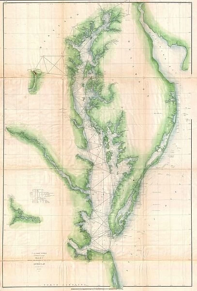
Canvas Print : 1855, U. S. Coast Survey Chart or Map of Chesapeake Bay and Delaware Bay, topography


![]()
Canvas Prints from Liszt Collection
1855, U. S. Coast Survey Chart or Map of Chesapeake Bay and Delaware Bay, topography
1855, U.S. Coast Survey Chart or Map of Chesapeake Bay and Delaware Bay
Liszt Collection of nineteenth-century engravings and images to browse and enjoy
Media ID 14007602
© Artokoloro Quint Lox Limited
1855 Antique Map Latitude Longitude Mappa Mundi Old Antique Plan Old Antique View Ols Antique Map Rare Old Maps Topo
30"x20" (76x51cm) Canvas Print
Bring the historical beauty of cartography into your home with our Media Storehouse Canvas Print of the 1855 U.S. Coast Survey Chart or Map of Chesapeake Bay and Delaware Bay from the Liszt Collection. This captivating canvas print showcases intricate topographical details of the Chesapeake Bay and Delaware Bay as they were documented over 160 years ago. Transport yourself back in time with this stunning piece, a perfect addition to any office, living room, or study. Experience the rich history of maritime exploration in your own space.
Delivered stretched and ready to hang our premium quality canvas prints are made from a polyester/cotton blend canvas and stretched over a 1.25" (32mm) kiln dried knot free wood stretcher bar. Packaged in a plastic bag and secured to a cardboard insert for safe transit.
Canvas Prints add colour, depth and texture to any space. Professionally Stretched Canvas over a hidden Wooden Box Frame and Ready to Hang
Estimated Product Size is 50.8cm x 76.2cm (20" x 30")
These are individually made so all sizes are approximate
Artwork printed orientated as per the preview above, with portrait (vertical) orientation to match the source image.
EDITORS COMMENTS
This vintage print captures the intricate details of an 1855 U. S. Coast Survey Chart or Map of Chesapeake Bay and Delaware Bay. A testament to the artistry of cartography, this topographical map showcases the stunning geography and land formations of these iconic bays. The illustration is a fascinating glimpse into history, offering a window into how early explorers navigated these waters. With its precise grid lines, latitude and longitude markings, and geometric accuracy, this chart served as an indispensable tool for sailors and travelers alike. Aesthetically pleasing with its aged paper texture and retro charm, this antique map exudes a sense of nostalgia for a bygone era. Its historical significance cannot be overstated; it represents not only a physical journey through space but also symbolizes the spirit of discovery that has shaped our understanding of the world. As part of the Liszt Collection's rare old maps series, this decorative piece adds depth to any collection or space. Whether you are an avid historian or simply appreciate artful representations of our planet's past, this print offers both beauty and educational value. Explore the region's rich heritage through this depiction that transcends time itself.
MADE IN AUSTRALIA
Safe Shipping with 30 Day Money Back Guarantee
FREE PERSONALISATION*
We are proud to offer a range of customisation features including Personalised Captions, Color Filters and Picture Zoom Tools
SECURE PAYMENTS
We happily accept a wide range of payment options so you can pay for the things you need in the way that is most convenient for you
* Options may vary by product and licensing agreement. Zoomed Pictures can be adjusted in the Cart.