Canvas Print > Arts > Artists > T > John Tallis
Canvas Print : Ireland 1851


![]()
Canvas Prints from MapSeeker
Ireland 1851
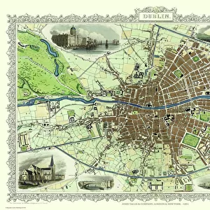
A fine facimile artworked from an antique original map of Ireland, issued as part of the 1851 edition of John Tallis and Companys " The Illustrated Atlas and Modern History of the World"
Welcome to the Mapseeker Image library and enter an historic gateway to one of the largest on-line collections of Historic Maps, Nostalgic Views, Vista's and Panorama's from a World gone by.
Media ID 20347396
© Mapseeker Publishing Ltd
John Tallis John Tallis Map Tallis Map
30"x20" (76x51cm) Canvas Print
Experience the rich history of Ireland with our stunning Canvas Print of "Ireland 1851" by John Tallis and John Rapkin from MapSeeker. This exquisite piece is a faithful reproduction of an original antique map from the 1851 edition of John Tallis and Company's "The Illustrated Atlas and Modern History of the World." Each detail of this map has been carefully artworks to bring out the intricate lines and vibrant colors of the original, transporting you back in time. Add this beautiful and educational addition to your home decor and let the story of Ireland's past come alive.
Delivered stretched and ready to hang our premium quality canvas prints are made from a polyester/cotton blend canvas and stretched over a 1.25" (32mm) kiln dried knot free wood stretcher bar. Packaged in a plastic bag and secured to a cardboard insert for safe transit.
Canvas Prints add colour, depth and texture to any space. Professionally Stretched Canvas over a hidden Wooden Box Frame and Ready to Hang
Estimated Product Size is 50.8cm x 76.2cm (20" x 30")
These are individually made so all sizes are approximate
Artwork printed orientated as per the preview above, with portrait (vertical) orientation to match the source image.
FEATURES IN THESE COLLECTIONS
> Arts
> Artists
> T
> John Tallis
> Europe
> Republic of Ireland
> Maps
> Maps and Charts
> Related Images
> Maps and Charts
> World
> MapSeeker
> Maps from the British Isles
> Ireland and Provinces PORTFOLIO
EDITORS COMMENTS
This exquisite print showcases a remarkable piece of history - an antique original map of Ireland from the year 1851. Painstakingly reproduced as a fine facsimile artwork, this map was originally issued as part of John Tallis and Company's renowned "The Illustrated Atlas and Modern History of the World". Transport yourself back in time to the mid-19th century with this depiction of Ireland. Every intricate detail has been faithfully preserved, allowing you to explore the island's geography, cities, towns, and landmarks just as they appeared over 170 years ago. As you study this old Irish map, it becomes evident that it is not merely a cartographic representation but also an invaluable historical artifact. It offers insights into how Ireland was perceived during that era and provides a glimpse into its rich cultural heritage. John Tallis and John Rapkin were esteemed cartographers who dedicated their lives to creating accurate maps that would stand the test of time. Their collaboration on this particular piece resulted in a work of art that seamlessly blends beauty with functionality. Whether you have Irish roots or simply appreciate the allure of vintage maps, this print will undoubtedly captivate your imagination. Hang it proudly on your wall or gift it to someone who shares your passion for history; either way, prepare to embark on a visual journey through Ireland's past like never before.
MADE IN AUSTRALIA
Safe Shipping with 30 Day Money Back Guarantee
FREE PERSONALISATION*
We are proud to offer a range of customisation features including Personalised Captions, Color Filters and Picture Zoom Tools
SECURE PAYMENTS
We happily accept a wide range of payment options so you can pay for the things you need in the way that is most convenient for you
* Options may vary by product and licensing agreement. Zoomed Pictures can be adjusted in the Cart.