Canvas Print > Europe > France > Paris > Maps
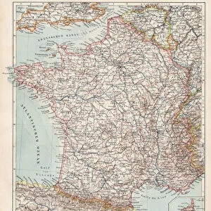
Canvas Print : 1878 Andriveau-Goujon Pocket Map Of Paris France


![]()
Canvas Prints from Universal Images Group (UIG)
1878 Andriveau-Goujon Pocket Map Of Paris France
1878, Andriveau-Goujon Pocket Map of Paris, France
Universal Images Group (UIG) manages distribution for many leading specialist agencies worldwide
Media ID 38549926
© Artokoloro Quint Lox Limited
1878 Antique Map Latitude Longitude Mappa Mundi Old Antique Plan Old Antique View Ols Antique Map Rare Old Maps Topo
20"x16" (51x41cm) Canvas Print
"Step back in time with our stunning Canvas Prints from the Media Storehouse range, featuring the iconic "1878 Andriveau-Goujon Pocket Map Of Paris, France". This beautifully reproduced print showcases a vintage map of the City of Light as it was over 140 years ago. With intricate details and charming illustrations, this unique piece of history is sure to delight anyone who loves Paris or collecting rare maps. Perfect for decorating your home or office with a touch of nostalgia and elegance.
Delivered stretched and ready to hang our premium quality canvas prints are made from a polyester/cotton blend canvas and stretched over a 1.25" (32mm) kiln dried knot free wood stretcher bar. Packaged in a plastic bag and secured to a cardboard insert for safe transit.
Canvas Prints add colour, depth and texture to any space. Professionally Stretched Canvas over a hidden Wooden Box Frame and Ready to Hang
Estimated Product Size is 50.8cm x 40.6cm (20" x 16")
These are individually made so all sizes are approximate
Artwork printed orientated as per the preview above, with landscape (horizontal) orientation to match the source image.
FEATURES IN THESE COLLECTIONS
> Animals
> Fishes
> G
> Grouper
> Europe
> France
> Canton
> Landes
> Europe
> France
> Paris
> Maps
> Historic
> Space exploration
> Maps and Charts
> Early Maps
> Maps and Charts
> Related Images
> Maps and Charts
> World
> Universal Images Group (UIG)
> History
> Historical Maps
EDITORS COMMENTS
Step into the charming streets of 19th century Paris with this exquisite print of the Andriveau-Goujon Pocket Map of Paris, France from 1878. This beautifully detailed map is a treasure trove of topographical and cartographical wonders, showcasing the City of Light in all its glory.
The intricate design features a wealth of information, including street names, landmarks, and notable buildings, making it an invaluable resource for travelers and history buffs alike. The vintage aesthetic adds a touch of nostalgia to this stunning piece, transporting you back to an era when maps were works of art in their own right.
As you gaze upon this antique map, imagine strolling along the Seine River or visiting iconic landmarks like Notre-Dame Cathedral or the Eiffel Tower. Every fold and crease tells a story of adventure and discovery, inviting you to explore the winding streets and hidden corners of this enchanting city.
This rare gem is not only a beautiful piece for your home or office but also a testament to human ingenuity and our enduring fascination with mapping our world. So why not take a step back in time and uncover the secrets hidden within these ancient lines?
MADE IN AUSTRALIA
Safe Shipping with 30 Day Money Back Guarantee
FREE PERSONALISATION*
We are proud to offer a range of customisation features including Personalised Captions, Color Filters and Picture Zoom Tools
SECURE PAYMENTS
We happily accept a wide range of payment options so you can pay for the things you need in the way that is most convenient for you
* Options may vary by product and licensing agreement. Zoomed Pictures can be adjusted in the Basket.