Canvas Print > Europe > France > Paris > Maps
Canvas Print : Galignani's Plan Of Paris And Environs France


![]()
Canvas Prints from Universal Images Group (UIG)
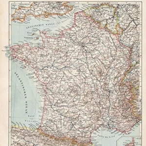
Galignani's Plan Of Paris And Environs France
Galignani's Plan of Paris and Environs, France
Universal Images Group (UIG) manages distribution for many leading specialist agencies worldwide
Media ID 38550080
© Artokoloro Quint Lox Limited
Antique Map Latitude Longitude Mappa Mundi Old Antique Plan Old Antique View Ols Antique Map Rare Old Maps Topo
20"x16" (51x41cm) Canvas Print
"Step into the City of Light with our stunning canvas print, 'Galignani's Plan Of Paris And Environs, France' from Universal Images Group (UIG). This beautiful piece of artistry captures the essence of 19th-century Paris, showcasing the city's iconic landmarks and charming streets. Printed on high-quality canvas for a premium finish, this unique piece is sure to be a conversation starter in any room. Perfect for history buffs, Francophiles, or anyone who loves vintage maps and architecture. Bring a touch of French elegance to your home decor with this exquisite canvas print."
Delivered stretched and ready to hang our premium quality canvas prints are made from a polyester/cotton blend canvas and stretched over a 1.25" (32mm) kiln dried knot free wood stretcher bar. Packaged in a plastic bag and secured to a cardboard insert for safe transit.
Canvas Prints add colour, depth and texture to any space. Professionally Stretched Canvas over a hidden Wooden Box Frame and Ready to Hang
Estimated Product Size is 50.8cm x 40.6cm (20" x 16")
These are individually made so all sizes are approximate
Artwork printed orientated as per the preview above, with landscape (horizontal) orientation to match the source image.
FEATURES IN THESE COLLECTIONS
> Animals
> Fishes
> G
> Grouper
> Europe
> France
> Canton
> Landes
> Europe
> France
> Paris
> Maps
> Historic
> Space exploration
> Maps and Charts
> Early Maps
> Maps and Charts
> Related Images
> Maps and Charts
> World
> Universal Images Group (UIG)
> History
> Historical Maps
EDITORS COMMENTS
Step into the City of Light with this stunning vintage print of Galignani's Plan of Paris and Environs, France. This beautifully illustrated map dates back to a bygone era, offering a unique glimpse into the geography and topography of 19th-century Paris. The intricate details on this chart reveal the city's layout, including its winding streets, grand boulevards, and iconic landmarks like the Eiffel Tower.
The map is adorned with elegant typography and ornate illustrations, showcasing the artistic skill of its creators. The grid-like pattern adds a touch of geometric precision to the design, while the use of latitude and longitude lines provides a sense of depth and dimensionality.
This rare old map is not only a fascinating piece for history buffs but also an exquisite work of art that can be treasured as a decorative piece in any room. It serves as a nostalgic reminder of past travels or inspires future adventures through its depiction of Paris' charming neighborhoods and picturesque surroundings.
As you gaze upon this vintage print, imagine strolling along the Seine River or exploring Montmartre's winding alleys. Let your imagination run wild as you discover hidden gems and secrets within this beautiful illustration. Whether you're an armchair traveler or an avid explorer, Galignani's Plan of Paris and Environs is sure to captivate your senses.
MADE IN AUSTRALIA
Safe Shipping with 30 Day Money Back Guarantee
FREE PERSONALISATION*
We are proud to offer a range of customisation features including Personalised Captions, Color Filters and Picture Zoom Tools
SECURE PAYMENTS
We happily accept a wide range of payment options so you can pay for the things you need in the way that is most convenient for you
* Options may vary by product and licensing agreement. Zoomed Pictures can be adjusted in the Cart.