Cushion > Historic > Ancient civilizations > Roman Empire > Roman art
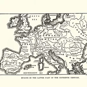
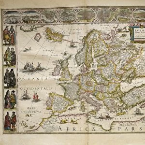
Cushion : Europe after the Peace Treaty in Westphalia (1648)
")
")

![]()
Home Decor from Fine Art Storehouse
Europe after the Peace Treaty in Westphalia (1648)
Illustration of a Europe after the Peace Treaty in Westphalia (1648)
Unleash your creativity and transform your space into a visual masterpiece!
Nastasic
Media ID 18298787
Cushion
Refresh your home decor with a beautiful full photo 16"x16" (40x40cm) cushion, complete with cushion pad insert. Printed on both sides and made from 100% polyester with a zipper on the bottom back edge of the cushion cover. Care Instructions: Warm machine wash, do not bleach, do not tumble dry. Warm iron inside out. Do not dry clean.
Accessorise your space with decorative, soft cushions
Estimated Product Size is 40cm x 40cm (15.7" x 15.7")
These are individually made so all sizes are approximate
Artwork printed orientated as per the preview above, with landscape (horizontal) or portrait (vertical) orientation to match the source image.
FEATURES IN THESE COLLECTIONS
> Arts
> Artists
> R
> Roman Roman
> Europe
> Related Images
> Historic
> Ancient civilizations
> Roman Empire
> Roman art
> Fine Art Storehouse
> Map
> Historical Maps
EDITORS COMMENTS
This print titled "Europe after the Peace Treaty in Westphalia (1648)" by Nastasic takes us back to a significant moment in history. The image beautifully illustrates the aftermath of the Peace Treaty signed in Westphalia, Germany, in 1648, which marked the end of the devastating Thirty Years' War. In this thought-provoking artwork, we are transported to a Europe that has emerged from years of conflict and turmoil. The artist skillfully depicts a continent transformed by diplomacy and compromise. Borders have been redrawn, nations have risen or fallen, and new alliances have been forged. The intricate details within this illustration allow us to explore various regions across Europe. We can observe how territories once controlled by the Holy Roman Empire now stand as independent states with their own distinct identities. From bustling cities adorned with magnificent architecture to serene countryside landscapes dotted with castles and villages, every element tells a story of resilience and renewal. Nastasic's artistic style brings vibrancy and life to this historical scene. Through his masterful use of color and composition, he captures both the grandeur of European civilization at that time and its fragility following such prolonged conflict. As we gaze upon this remarkable piece, we cannot help but reflect on the power of diplomacy in shaping our world today. It serves as a reminder that even amidst chaos and destruction, peace can be achieved through dialogue and understanding – an enduring message for generations to come.
MADE IN AUSTRALIA
Safe Shipping with 30 Day Money Back Guarantee
FREE PERSONALISATION*
We are proud to offer a range of customisation features including Personalised Captions, Color Filters and Picture Zoom Tools
SECURE PAYMENTS
We happily accept a wide range of payment options so you can pay for the things you need in the way that is most convenient for you
* Options may vary by product and licensing agreement. Zoomed Pictures can be adjusted in the Cart.