Cushion > Asia > Turkey > Related Images
Cushion : europe map 1829


![]()
Home Decor from Fine Art Storehouse
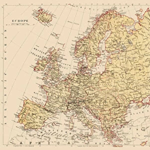
europe map 1829
an old map form 1829, showing the whole europe
Unleash your creativity and transform your space into a visual masterpiece!
THEPALMER
Media ID 15134763
© Roberto A Sanchez
Austria Backgrounds Burnt Direction European Community Grunge Map03 Mediterranean Countries Mediterranean Sea National Border Paper Patina Retro Revival Russia Rust Rusty Sepia Toned Textured Effect Torn Turkey Obsolete
Cushion
Refresh your home decor with a beautiful full photo 16"x16" (40x40cm) cushion, complete with cushion pad insert. Printed on both sides and made from 100% polyester with a zipper on the bottom back edge of the cushion cover. Care Instructions: Warm machine wash, do not bleach, do not tumble dry. Warm iron inside out. Do not dry clean.
Accessorise your space with decorative, soft cushions
Estimated Product Size is 40cm x 40cm (15.7" x 15.7")
These are individually made so all sizes are approximate
Artwork printed orientated as per the preview above, with landscape (horizontal) or portrait (vertical) orientation to match the source image.
FEATURES IN THESE COLLECTIONS
> Asia
> Turkey
> Related Images
> Europe
> Austria
> Related Images
> Europe
> Italy
> Related Images
> Europe
> Related Images
> Fine Art Storehouse
> Map
> Historical Maps
> Fine Art Storehouse
> Map
> Italian Maps
EDITORS COMMENTS
This print takes us back in time to the year 1829, showcasing an old map of Europe. The intricate details and craftsmanship of this cartographic masterpiece are truly remarkable. As we gaze upon it, we are transported to a bygone era when national borders were different, and the European community as we know it today was yet to be formed. The sepia-toned image gives the map a nostalgic feel, while the textured effect adds depth and character. The paper appears worn and torn in places, revealing its age and history. Rusty hues blend with burnt backgrounds, creating a unique patina that enhances the overall vintage aesthetic. Our eyes wander across this ancient map, tracing familiar countries such as Spain, Italy, Austria, France, England - each marked with their own distinct boundaries. We can't help but notice Turkey's vast presence on one side while Russia looms large on another. The Mediterranean Sea stands out prominently at the center of this composition - its azure waters contrasting against the faded surroundings. This piece captures not only physical geography but also evokes a sense of nostalgia for a time long past. "The Europe Map 1829" is more than just a historical artifact; it is an artful representation of our collective heritage. THEPALMER has skillfully captured its essence through his lens – preserving both its beauty and significance for generations to come.
MADE IN AUSTRALIA
Safe Shipping with 30 Day Money Back Guarantee
FREE PERSONALISATION*
We are proud to offer a range of customisation features including Personalised Captions, Color Filters and Picture Zoom Tools
SECURE PAYMENTS
We happily accept a wide range of payment options so you can pay for the things you need in the way that is most convenient for you
* Options may vary by product and licensing agreement. Zoomed Pictures can be adjusted in the Cart.