Home > Europe > Austria > Maps
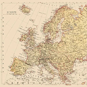
Europe map 1881

![]()
Wall Art and Photo Gifts from Fine Art Storehouse
Europe map 1881
Coltons Common School Geography 1881 New York Sheldon and Co
Unleash your creativity and transform your space into a visual masterpiece!
THEPALMER
Media ID 13669303
© This content is subject to copyright
Austria Denmark Globe Navigational Equipment Norway Paper Planet Earth Portugal Russia Sweden World Map
FEATURES IN THESE COLLECTIONS
> Fine Art Storehouse
> The Magical World of Illustration
> Palmer Illustrated Collection
> Fine Art Storehouse
> Map
> Denmark Maps
> Fine Art Storehouse
> Map
> Historical Maps
> Fine Art Storehouse
> Map
> Italian Maps
> Fine Art Storehouse
> Map
> USA Maps
EDITORS COMMENTS
In this print titled "Europe map 1881" we are transported back in time to the late 19th century, where cartography and exploration were at their peak. The image showcases a beautifully detailed map of Europe from Coltons Common School Geography, published in New York by Sheldon and Co. in 1881. This vintage piece takes us on a journey across the continent, highlighting countries such as Russia, France, Denmark, Norway, Sweden, Austria, Germany, Italy, Portugal, Spain and even includes the United States for comparison. The intricate engravings depict physical geography with precision and accuracy. The aged paper adds an authentic touch to this antique illustration that is rich in history. As we gaze upon this engraved image of our planet Earth's landmasses during a significant period of time over a century ago; it reminds us of how far we have come since then. The presence of globe navigational equipment further emphasizes the importance of maps during that era when explorers relied heavily on these tools to navigate uncharted territories. This print serves as both a beautiful decorative piece for any space and an educational reminder of our world's ever-evolving nature. "The Europe map 1881" by THEPALMER captures not only the artistry involved in cartography but also allows us to appreciate the knowledge gained through centuries-old geographical discoveries. It stands as a testament to human curiosity and determination to understand our planet better.
MADE IN AUSTRALIA
Safe Shipping with 30 Day Money Back Guarantee
FREE PERSONALISATION*
We are proud to offer a range of customisation features including Personalised Captions, Color Filters and Picture Zoom Tools
SECURE PAYMENTS
We happily accept a wide range of payment options so you can pay for the things you need in the way that is most convenient for you
* Options may vary by product and licensing agreement. Zoomed Pictures can be adjusted in the Cart.