Cushion > Animals > Mammals > Cats (Wild) > Populator
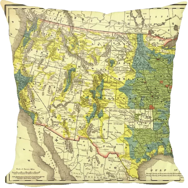
Cushion : Rand, McNally & Co.'s map of the United States showing, in six degrees the density of pop... 1890. Creator: Rand McNally. Rand, McNally & Co.'s map of the United States showing, in six degrees the density of pop... 1890. Creator: Rand McNally
![]()

Home Decor from Heritage Images
Rand, McNally & Co.'s map of the United States showing, in six degrees the density of pop... 1890. Creator: Rand McNally. Rand, McNally & Co.'s map of the United States showing, in six degrees the density of pop... 1890. Creator: Rand McNally
Rand, McNally & Co.'s map of the United States showing, in six degrees the density of population, 1890, (1892). This map, published in 1892 by the Chicago-based Rand McNally and Company, shows the population density of the United States in 1890. Six shades of color are used to indicate the different levels of population density by location, ranging from fewer than two inhabitants per square mile (2.59 square kilometers) to more than 90 inhabitants per square mile. The most densely populated parts of the country are in the Northeast and parts of the Midwest. The West is for the most part sparsely populated, although already by this time Denver, Los Angeles, Salt Lake City, San Francisco, and Seattle are emerging as major cities. Red stars are used to indicate the westward movement of the country's center of population, caused by a century of migration and settlement. A note at the bottom explains that in 1890 the overall population density of the United States (excluding Alaska) was 20.77 inhabitants per square mile, up from 16.58 inhabitants per square mile a decade earlier. Also shown are major geographic features including national and state borders, mountains, rivers and lakes, major roads, cities and towns, national parks, and Indian reservations
Heritage Images features heritage image collections
Media ID 35129393
© Heritage Art/Heritage Images
Border Borders Cartographic Cartography Cities Inhabitant Lakes Map Making Mapmaking Migrating Migration National Park Population Reservation Rivers Roads San Francisco California Usa Settlement Thoroughfare Density Meeting Of Frontiers Salt Lake City Utah
Cushion
Refresh your home decor with a beautiful full photo 16"x16" (40x40cm) cushion, complete with cushion pad insert. Printed on both sides and made from 100% polyester with a zipper on the bottom back edge of the cushion cover. Care Instructions: Warm machine wash, do not bleach, do not tumble dry. Warm iron inside out. Do not dry clean.
Accessorise your space with decorative, soft cushions
Estimated Product Size is 40cm x 40cm (15.7" x 15.7")
These are individually made so all sizes are approximate
Artwork printed orientated as per the preview above, with landscape (horizontal) or portrait (vertical) orientation to match the source image.
FEATURES IN THESE COLLECTIONS
> Animals
> Mammals
> Cats (Wild)
> Populator
> Animals
> Mammals
> Cricetidae
> California Mouse
> Arts
> Landscape paintings
> Waterfall and river artworks
> River artworks
> Arts
> Portraits
> Pop art gallery
> Fine art gallery
> Arts
> Portraits
> Pop art gallery
> Street art portraits
> Maps and Charts
> Early Maps
> Maps and Charts
> Related Images
> North America
> United States of America
> Alaska
> Related Images
Rand McNally & Co.'s Map of the United States Showing, in Six Degrees the Density of Population, 1890
EDITORS COMMENTS
is a historical map published by the Chicago-based Rand McNally and Company in 1892. This map offers a unique perspective on the population distribution in the United States during that time. Six distinct shades of color represent varying levels of population density, ranging from less than two inhabitants per square mile to over 90 inhabitants per square mile. The map reveals that the most densely populated areas were primarily located in the Northeast and parts of the Midwest. In contrast, the Western regions were mostly sparsely populated, although major cities such as Denver, Los Angeles, Salt Lake City, San Francisco, and Seattle were already beginning to emerge. Red stars on the map mark the westward movement of the country's center of population, indicating the significant impact of a century of migration and settlement. The overall population density of the United States (excluding Alaska) in 1890 was 20.77 inhabitants per square mile, a marked increase from the 16.58 inhabitants per square mile recorded a decade earlier. The map also showcases major geographic features, including national and state borders, mountains, rivers and lakes, major roads, cities and towns, national parks, and Indian reservations. This fascinating historical artifact provides valuable insights into the demographic shifts and geographic characteristics of the United States during the late 19th century.
MADE IN AUSTRALIA
Safe Shipping with 30 Day Money Back Guarantee
FREE PERSONALISATION*
We are proud to offer a range of customisation features including Personalised Captions, Color Filters and Picture Zoom Tools
SECURE PAYMENTS
We happily accept a wide range of payment options so you can pay for the things you need in the way that is most convenient for you
* Options may vary by product and licensing agreement. Zoomed Pictures can be adjusted in the Cart.


