Cushion > Arts > Artists > T > John Tallis
Cushion : Old Map of York 1851 by John Tallis


![]()
Home Decor from MapSeeker
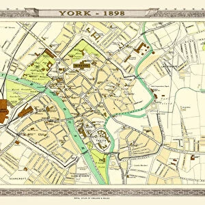
Old Map of York 1851 by John Tallis
The River Ouse flows through the famous City of York, already its buildings are spreading outside its ancient walls. The 1851 John Tallis plan is illustrated with views of The Minster, Walmgate Bar, Archbishops Palace, The Castle, Museum, York Railway Station, Micklegate Bar, Ruins of St Marys Abbey, Guildhall and Ouse Bridge
Welcome to the Mapseeker Image library and enter an historic gateway to one of the largest on-line collections of Historic Maps, Nostalgic Views, Vista's and Panorama's from a World gone by.
Media ID 20347622
Historic Map John Tallis John Tallis Map Old Town Plan Tallis Map York York City
Cushion
Refresh your home decor with a beautiful full photo 16"x16" (40x40cm) cushion, complete with cushion pad insert. Printed on both sides and made from 100% polyester with a zipper on the bottom back edge of the cushion cover. Care Instructions: Warm machine wash, do not bleach, do not tumble dry. Warm iron inside out. Do not dry clean.
Accessorise your space with decorative, soft cushions
Estimated Product Size is 40cm x 40cm (15.7" x 15.7")
These are individually made so all sizes are approximate
Artwork printed orientated as per the preview above, with landscape (horizontal) or portrait (vertical) orientation to match the source image.
FEATURES IN THESE COLLECTIONS
> Arts
> Artists
> T
> John Tallis
> Historic
> Medieval architecture
> Castles and fortresses
> Castle ruins
> Historic
> Medieval architecture
> Castles and fortresses
> Historic castles
> Maps and Charts
> Early Maps
> Maps and Charts
> Related Images
> Popular Themes
> Railway Posters
> MapSeeker
> British Town And City Plans
> English & Welsh PORTFOLIO
EDITORS COMMENTS
This print showcases the "Old Map of York 1851" by John Tallis, offering a glimpse into the rich history and architectural beauty of this famous city. The River Ouse gracefully flows through York, while its buildings have already begun to extend beyond the ancient walls that once enclosed it. John Tallis's meticulously detailed plan from 1851 provides an enchanting visual journey through York's past. The map is adorned with stunning illustrations featuring iconic landmarks such as The Minster, Walmgate Bar, Archbishops Palace, The Castle, Museum, York Railway Station, Micklegate Bar, Ruins of St Marys Abbey, Guildhall and Ouse Bridge. As you gaze upon this historic map of York City, you can't help but be transported back in time to an era when these structures stood proudly amidst a bustling town center. Each building tells a story and holds within it centuries of memories. Whether you are a history enthusiast or simply appreciate the charm of old-world cartography, this print will undoubtedly captivate your imagination. It serves as a reminder that even though time may pass and cities may evolve and expand their boundaries like York did since 1851; their essence remains etched in maps like these – preserving their unique character for generations to come.
MADE IN AUSTRALIA
Safe Shipping with 30 Day Money Back Guarantee
FREE PERSONALISATION*
We are proud to offer a range of customisation features including Personalised Captions, Color Filters and Picture Zoom Tools
SECURE PAYMENTS
We happily accept a wide range of payment options so you can pay for the things you need in the way that is most convenient for you
* Options may vary by product and licensing agreement. Zoomed Pictures can be adjusted in the Cart.