Cushion > Europe > France > Canton > Landes
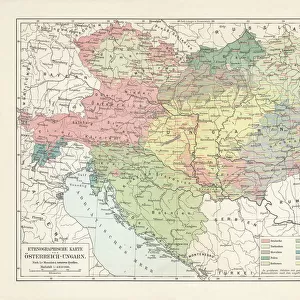
Cushion : 1747 La Feuille Map Of Hungary Topography Cartography


![]()
Home Decor From Universal Images Group (UIG)
1747 La Feuille Map Of Hungary Topography Cartography
1747, La Feuille Map of Hungary
Universal Images Group (UIG) manages distribution for many leading specialist agencies worldwide
Media ID 38550216
© Artokoloro Quint Lox Limited
1747 Antique Map Latitude Longitude Mappa Mundi Old Antique Plan Old Antique View Ols Antique Map Rare Old Maps Topo
Cushion
Refresh your home decor with a beautiful full photo 16"x16" (40x40cm) cushion, complete with cushion pad insert. Printed on both sides and made from 100% polyester with a zipper on the bottom back edge of the cushion cover. Care Instructions: Warm machine wash, do not bleach, do not tumble dry. Warm iron inside out. Do not dry clean.
Accessorise your space with decorative, soft cushions
Estimated Product Size is 40cm x 40cm (15.7" x 15.7")
These are individually made so all sizes are approximate
Artwork printed orientated as per the preview above, with landscape (horizontal) or portrait (vertical) orientation to match the source image.
FEATURES IN THESE COLLECTIONS
> Animals
> Fishes
> G
> Grouper
> Europe
> France
> Canton
> Landes
> Europe
> Hungary
> Related Images
> Historic
> Space exploration
> Maps and Charts
> Early Maps
> Maps and Charts
> Related Images
> Maps and Charts
> World
> Universal Images Group (UIG)
> History
> Historical Maps
EDITORS COMMENTS
Step back in time to the 18th century with this stunning print of the 1747 La Feuille Map of Hungary Topography Cartography. This exquisite illustration is a testament to the artistry and precision of cartographers during a bygone era.
The map depicts the geographical landscape of Hungary, showcasing its mountains, rivers, forests, and cities with remarkable detail. The intricate design features a grid system, allowing for precise navigation and measurement. The use of vibrant colors adds depth and visual interest to the piece.
This historic map not only provides insight into Hungary's topography but also serves as a window into the country's cultural and economic development during that time period. It would be an excellent addition to any collection or study on geography, history, or cartography.
Printed on high-quality paper, this vintage map has been carefully preserved to maintain its original charm. Its aged appearance adds character and uniqueness to any room or office decor. Whether you're an enthusiast of ancient maps or simply appreciate beautiful illustrations, this print is sure to captivate.
MADE IN AUSTRALIA
Safe Shipping with 30 Day Money Back Guarantee
FREE PERSONALISATION*
We are proud to offer a range of customisation features including Personalised Captions, Color Filters and Picture Zoom Tools
SECURE PAYMENTS
We happily accept a wide range of payment options so you can pay for the things you need in the way that is most convenient for you
* Options may vary by product and licensing agreement. Zoomed Pictures can be adjusted in the Basket.