Cushion > Europe > France > Canton > Landes
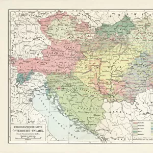
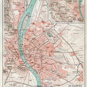
Cushion : 1850 Mitchell Map Of Austria Hungary And Transylvania


![]()
Home Decor From Universal Images Group (UIG)
1850 Mitchell Map Of Austria Hungary And Transylvania
1850, Mitchell Map of Austria, Hungary and Transylvania
Universal Images Group (UIG) manages distribution for many leading specialist agencies worldwide
Media ID 38548721
© Artokoloro Quint Lox Limited
1850 Antique Map Latitude Longitude Mappa Mundi Old Antique Plan Old Antique View Ols Antique Map Rare Old Maps Topo
Cushion
Refresh your home decor with a beautiful full photo 16"x16" (40x40cm) cushion, complete with cushion pad insert. Printed on both sides and made from 100% polyester with a zipper on the bottom back edge of the cushion cover. Care Instructions: Warm machine wash, do not bleach, do not tumble dry. Warm iron inside out. Do not dry clean.
Accessorise your space with decorative, soft cushions
Estimated Product Size is 40cm x 40cm (15.7" x 15.7")
These are individually made so all sizes are approximate
Artwork printed orientated as per the preview above, with landscape (horizontal) or portrait (vertical) orientation to match the source image.
FEATURES IN THESE COLLECTIONS
> Animals
> Fishes
> G
> Grouper
> Europe
> Austria
> Related Images
> Europe
> France
> Canton
> Landes
> Europe
> Hungary
> Related Images
> Historic
> Space exploration
> Maps and Charts
> Early Maps
> Universal Images Group (UIG)
> History
> Historical Maps
EDITORS COMMENTS
Step back in time and explore the intricate details of this stunning 1850 Mitchell Map of Austria, Hungary, and Transylvania. This vintage print is a true masterpiece of cartography, showcasing the geographic boundaries and topographical features of this region with remarkable precision.
The map's creator, Samuel Augustus Mitchell, was a renowned American cartographer who was known for his meticulous attention to detail and commitment to accuracy. This particular map is a testament to his skill, featuring beautifully rendered illustrations of mountains, rivers, forests, and cities.
As you gaze upon this ancient chart, you can almost hear the whispers of history as it unfolds before your eyes. The map provides a glimpse into a bygone era when empires rose and fell, cultures collided, and borders shifted like sand dunes in the wind.
This historic print is not only a fascinating piece of geographical art but also a window into the past. It invites us to imagine life in another time and place - where horse-drawn carriages rattled along cobblestone streets; where monarchs ruled with absolute power; where wars raged across distant battlefields; and where explorers ventured forth into uncharted territories.
Whether you're an armchair traveler or an avid historian, this 1850 Mitchell Map of Austria-Hungary-Transylvania is sure to captivate your imagination. Its aged beauty serves as a poignant reminder that even as we navigate our modern world with GPS devices at our fingertips - there remains something timeless about exploring the intricacies of human geography.
MADE IN AUSTRALIA
Safe Shipping with 30 Day Money Back Guarantee
FREE PERSONALISATION*
We are proud to offer a range of customisation features including Personalised Captions, Color Filters and Picture Zoom Tools
SECURE PAYMENTS
We happily accept a wide range of payment options so you can pay for the things you need in the way that is most convenient for you
* Options may vary by product and licensing agreement. Zoomed Pictures can be adjusted in the Basket.