Home > Arts > Artists > C > Abraham Cresques
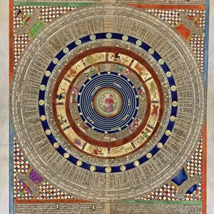
Catalan Atlas (reproduction)
")
![]()
Wall Art and Photo Gifts from Fine Art Finder
Catalan Atlas (reproduction)
5054666 Catalan Atlas (reproduction) by Cresques, Abraham (1325-87) (after); (add.info.: Reproduction of 1375 World map made in Majorca, attributed to the Jewish cartographer Abraham Cresques
The first two leaves contain texts in Catalan covering cosmography, astronomy, and astrology, emphasizing the Earths spherical shape, giving information about the state of the known world plus (for sailors) tides and how to tell time at night.); Spanish, out of copyright
Media ID 22564996
© Bridgeman Images
Atlas Cartography Catalan Catalan Atlas Catalonia Cosmography Early Map Earth Hydrography Majorcan Mappa Mundi Nautical Nautical Charts Navigation Navigational Portolan Sea Chart Silk Road Spice Trade Vellum World Map
FEATURES IN THESE COLLECTIONS
> Arts
> Artists
> C
> Abraham Cresques
> Arts
> Artists
> Edouard Manet
> Arts
> Artists
> M
> Edouard Manet
> Fine Art Finder
> Artists
> Abraham (after) Cresques
> Fine Art Finder
> Artists
> Edouard Manet
> Maps and Charts
> Early Maps
> Maps and Charts
> Spain
> Maps and Charts
> World
EDITORS COMMENTS
This print showcases a reproduction of the renowned "Catalan Atlas" created by Abraham Cresques, a Jewish cartographer from Majorca in the 14th century. The atlas, dating back to 1375, is an extraordinary world map that provides invaluable insights into medieval cosmography and navigation techniques. The Catalan Atlas reproduction consists of two leaves adorned with texts written in Catalan. These texts delve into various subjects such as cosmography, astronomy, and astrology. They emphasize the spherical shape of the Earth while offering sailors essential information about tides and nocturnal timekeeping methods. This historic masterpiece sheds light on the state of knowledge during that era and offers glimpses into trade routes like the Silk Road and maritime exploration. With its intricate details and meticulous craftsmanship, this early map serves as a testament to Spain's rich history in cartography. Crafted on vellum using portolan charts, this remarkable piece captures not only geographical features but also highlights major trading centers along with their respective commodities. It stands as a testimony to Catalonia's significant contributions to medieval maritime endeavors. As we gaze upon this mesmerizing image captured by Bridgeman Images, we are transported back in time to an age when maps were not just navigational tools but works of art that encapsulated human curiosity about our vast world.
MADE IN AUSTRALIA
Safe Shipping with 30 Day Money Back Guarantee
FREE PERSONALISATION*
We are proud to offer a range of customisation features including Personalised Captions, Color Filters and Picture Zoom Tools
SECURE PAYMENTS
We happily accept a wide range of payment options so you can pay for the things you need in the way that is most convenient for you
* Options may vary by product and licensing agreement. Zoomed Pictures can be adjusted in the Cart.