Fraud Blocker Skip to main content

Catalan Atlas Collection

The Catalan Atlas, created in the 14th century, is a remarkable piece of cartographic history

Background imageCatalan Atlas Collection: Catalan Atlas, 14th century

Catalan Atlas, 14th century. The 6-page Catalan Atlas (1375) was produced on vellum by the Jewish cartographer Abraham Cresques

Background imageCatalan Atlas Collection: MANSA MUSA (1312-1337). King of Mali. Mansa Musa seated on his throne

MANSA MUSA (1312-1337). King of Mali. Mansa Musa seated on his throne. Facing him is a Tuareg on his camel. Detail from the Catalan Atlas of 1375

Background imageCatalan Atlas Collection: Map of Cathay, China, from Catalan Atlas created for Charles V, King of France

Map of Cathay, China, from Catalan Atlas created for Charles V, King of France
Cartography, 14th century. Map of Cathay (China). From Catalan Atlas created for Charles V, King of France, attributed to Abraham and Jafuda Cresques Maiorca (circa 1375)

Background imageCatalan Atlas Collection: Catalan Atlas (reproduction)

Catalan Atlas (reproduction)
5054662 Catalan Atlas (reproduction) by Cresques, Abraham (1325-87) (after); (add.info.: Reproduction of 1375 World map made in Majorca)

Background imageCatalan Atlas Collection: Caravan on the Silk Road. Detail from the Catalan Atlas

Caravan on the Silk Road. Detail from the Catalan Atlas. Found in the Collection of Bibliotheque Nationale de France

Background imageCatalan Atlas Collection: Catalan Atlas, Sheet 10, 1375 (pen with coloured inks on parchment)

Catalan Atlas, Sheet 10, 1375 (pen with coloured inks on parchment)
5054670 Catalan Atlas, Sheet 10, 1375 (pen with coloured inks on parchment) by Cresques, Abraham (1325-87); Bibliotheque Nationale, Paris, France; (add.info.: World map made in Majorca)

Background imageCatalan Atlas Collection: Catalan Atlas, Sheet 9, 1375 (pen and coloured inks on parchment)

Catalan Atlas, Sheet 9, 1375 (pen and coloured inks on parchment)
5054647 Catalan Atlas, Sheet 9, 1375 (pen and coloured inks on parchment) by Cresques, Abraham (1325-87); Bibliotheque Nationale, Paris, France; (add.info.: World map made in Majorca)

Background imageCatalan Atlas Collection: Catalan Atlas, Sheet 12, 1375 (pen and coloured inks on parchment)

Catalan Atlas, Sheet 12, 1375 (pen and coloured inks on parchment)
5054646 Catalan Atlas, Sheet 12, 1375 (pen and coloured inks on parchment) by Cresques, Abraham (1325-87); Bibliotheque Nationale, Paris, France; (add.info.: World map made in Majorca)

Background imageCatalan Atlas Collection: Catalan Atlas, Sheet 11, 1375 (pen with coloured inks on parchment)

Catalan Atlas, Sheet 11, 1375 (pen with coloured inks on parchment)
5054644 Catalan Atlas, Sheet 11, 1375 (pen with coloured inks on parchment) by Cresques, Abraham (1325-87); Bibliotheque Nationale, Paris, France; (add.info.: World map made in Majorca)

Background imageCatalan Atlas Collection: Four vellum leaves of the Catalan Atlas, 1375 (pen and coloured inks on parchment)

Four vellum leaves of the Catalan Atlas, 1375 (pen and coloured inks on parchment)
5895292 Four vellum leaves of the Catalan Atlas, 1375 (pen and coloured inks on parchment) by Cresques, Abraham (1325-87); Bibliotheque Nationale, Paris

Background imageCatalan Atlas Collection: Catalan Atlas, Sheet 8 (pen with coloured inks on parchment)

Catalan Atlas, Sheet 8 (pen with coloured inks on parchment)
5054649 Catalan Atlas, Sheet 8 (pen with coloured inks on parchment) by Cresques, Abraham (1325-87); Bibliotheque Nationale, Paris, France; (add.info.: World map made in Majorca)

Background imageCatalan Atlas Collection: Catalan Atlas, Sheet 2, 1375 (pen with coloured inks on parchment)

Catalan Atlas, Sheet 2, 1375 (pen with coloured inks on parchment)
5054640 Catalan Atlas, Sheet 2, 1375 (pen with coloured inks on parchment) by Cresques, Abraham (1325-87); Bibliotheque Nationale, Paris

Background imageCatalan Atlas Collection: Catalan Atlas, Sheet 6, 1375 (pen with coloured inks on parchment)

Catalan Atlas, Sheet 6, 1375 (pen with coloured inks on parchment)
5054638 Catalan Atlas, Sheet 6, 1375 (pen with coloured inks on parchment) by Cresques, Abraham (1325-87); Bibliotheque Nationale, Paris, France; (add.info.: World map made in Majorca)

Background imageCatalan Atlas Collection: Detail from the Catalan Atlas, Sheet 6, showing the Western Sahara and Mansa Musa

Detail from the Catalan Atlas, Sheet 6, showing the Western Sahara and Mansa Musa
5054637 Detail from the Catalan Atlas, Sheet 6, showing the Western Sahara and Mansa Musa, 1375 (pen with coloured inks on parchment) by Cresques, Abraham (1325-87); Bibliotheque Nationale, Paris

Background imageCatalan Atlas Collection: Catalan Atlas, Sheet 7 and 8, 1375 (pen with coloured inks on parchment)

Catalan Atlas, Sheet 7 and 8, 1375 (pen with coloured inks on parchment)
5054639 Catalan Atlas, Sheet 7 and 8, 1375 (pen with coloured inks on parchment) by Cresques, Abraham (1325-87); Bibliotheque Nationale, Paris, France; (add.info.: World map made in Majorca)

Background imageCatalan Atlas Collection: North Africa, Europe and the Middle East from the Catalan Atlas (reproduction)

North Africa, Europe and the Middle East from the Catalan Atlas (reproduction)
5054659 North Africa, Europe and the Middle East from the Catalan Atlas (reproduction) by Cresques, Abraham (1325-87) (after); (add.info)

Background imageCatalan Atlas Collection: Detail from the Catalan Atlas, Sheet 6, showing Mansa Musa enthroned

Detail from the Catalan Atlas, Sheet 6, showing Mansa Musa enthroned
5043052 Detail from the Catalan Atlas, Sheet 6, showing Mansa Musa enthroned, 1375 (pen with coloured inks on parchment) by Cresques, Abraham (1325-87); Bibliotheque Nationale, Paris

Background imageCatalan Atlas Collection: Catalan Atlas (reproduction)

Catalan Atlas (reproduction)
5054666 Catalan Atlas (reproduction) by Cresques, Abraham (1325-87) (after); (add.info.: Reproduction of 1375 World map made in Majorca)

Background imageCatalan Atlas Collection: Catalan Atlas, Sheet 1, 1375 (pen and coloured inks on parchment)

Catalan Atlas, Sheet 1, 1375 (pen and coloured inks on parchment)
5054645 Catalan Atlas, Sheet 1, 1375 (pen and coloured inks on parchment) by Cresques, Abraham (1325-87); Bibliotheque Nationale, Paris

Background imageCatalan Atlas Collection: Catalan Atlas, Sheet 5, 1375 (pen and coloured inks on parchment)

Catalan Atlas, Sheet 5, 1375 (pen and coloured inks on parchment)
5054641 Catalan Atlas, Sheet 5, 1375 (pen and coloured inks on parchment) by Cresques, Abraham (1325-87); Bibliotheque Nationale, Paris, France; (add.info.: World map made in Majorca)

Background imageCatalan Atlas Collection: Catalan Atlas, Sheet 7, 1375 (pen and coloured inks on parchment)

Catalan Atlas, Sheet 7, 1375 (pen and coloured inks on parchment)
5054643 Catalan Atlas, Sheet 7, 1375 (pen and coloured inks on parchment) by Cresques, Abraham (1325-87); Bibliotheque Nationale, Paris, France; (add.info.: World map made in Majorca)

Background imageCatalan Atlas Collection: Cathay, China from the Catalan Atlas (reproduction)

Cathay, China from the Catalan Atlas (reproduction)
5054664 Cathay, China from the Catalan Atlas (reproduction) by Cresques, Abraham (1325-87) (after); (add.info.: Detail from the reproduction of 1375 World map made in Majorca)

Background imageCatalan Atlas Collection: Catalan Atlas, Sheet 4 (pen with coloured inks on parchment)

Catalan Atlas, Sheet 4 (pen with coloured inks on parchment)
5054648 Catalan Atlas, Sheet 4 (pen with coloured inks on parchment) by Cresques, Abraham (1325-87); Bibliotheque Nationale, Paris

Background imageCatalan Atlas Collection: Catalan Atlas, Sheet 3, 1375 (pen and coloured inks on parchment)

Catalan Atlas, Sheet 3, 1375 (pen and coloured inks on parchment)
5054642 Catalan Atlas, Sheet 3, 1375 (pen and coloured inks on parchment) by Cresques, Abraham (1325-87); Bibliotheque Nationale, Paris

Background imageCatalan Atlas Collection: Mapamundi. Calendar

Mapamundi. Calendar. Found in the Collection of Bibliotheque Nationale de France

Background imageCatalan Atlas Collection: MANSA MUSA (1312-1337). King of Mali. Mansa Musa seated on his throne

MANSA MUSA (1312-1337). King of Mali. Mansa Musa seated on his throne. Facing him is a Tuareg on his camel. Detail from the Catalan Atlas of 1375

Background imageCatalan Atlas Collection: CHINA: MAP, 1375. Detail from the Catalan Atlas, 1375, showing China and the Grand

CHINA: MAP, 1375. Detail from the Catalan Atlas, 1375, showing China and the Grand Canal

Background imageCatalan Atlas Collection: Ms Esp 20 panel 4, Merchants travelling to Cathay, China, following in Marco Polos footsteps

Ms Esp 20 panel 4, Merchants travelling to Cathay, China, following in Marco Polos footsteps
XIR158651 Ms Esp 20 panel 4, Merchants travelling to Cathay, China, following in Marco Polos footsteps, detail showing the family of Marco Polo traveling by camel caravan

Background imageCatalan Atlas Collection: Map of Western Europe, North-western Africa and Atlantic Ocean

Map of Western Europe, North-western Africa and Atlantic Ocean, from Catalan Atlas created for Charles V
Cartography, 14th century. Map of Western Europe, North-western Africa and Atlantic Ocean. From Catalan Atlas created for Charles V, King of France, attributed to Abraham and Jafuda Cresques Maiorca


All Professionally Made to Order for Quick Shipping

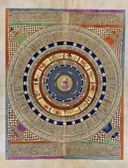
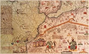
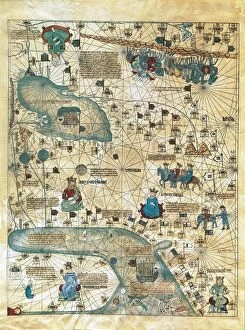
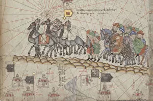
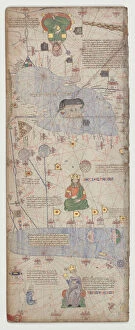
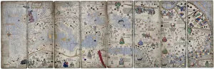
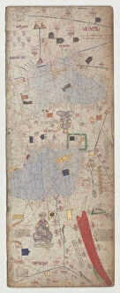
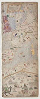
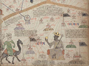
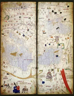
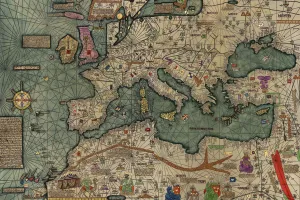
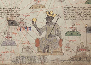
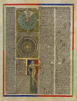
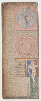
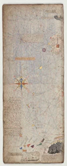
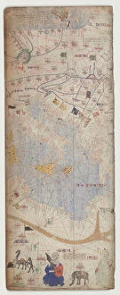
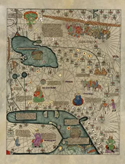
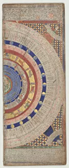
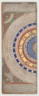
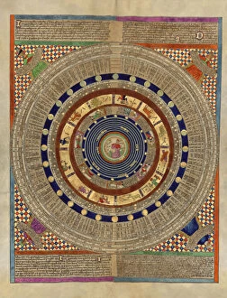
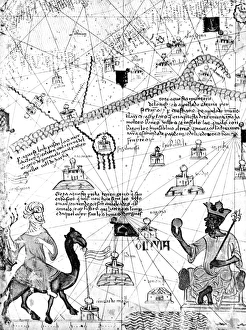
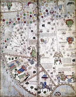
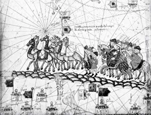
The Catalan Atlas, created in the 14th century, is a remarkable piece of cartographic history. This magnificent map, attributed to Abraham and Jafuda Cresques Maiorca, was crafted for Charles V, King of France. The Catalan Atlas consists of several sheets made from pen and colored inks on parchment. Sheet 10 showcases a detailed depiction of Cathay, China. With intricate illustrations and precise geographical markings, it offers a glimpse into the ancient world as seen through the eyes of medieval cartographers. Sheet 9 presents another captivating view with its vibrant colors and meticulous craftsmanship. Every stroke on this sheet tells a story about the lands it represents. Moving forward to Sheet 12, one can marvel at how this work captures the essence of exploration during that era. It transports us back in time when adventurers set sail into uncharted territories. Continuing our journey through these historical maps brings us to Sheet 11. Its delicate lines reveal an intricate network connecting different regions across vast distances. Four vellum leaves from the Catalan Atlas provide further insight into this masterpiece's grandeur. These pages showcase not only artistic brilliance but also serve as valuable artifacts documenting our understanding of geography at that time. Sheet 8 invites us to explore new horizons with its richly illustrated landscapes and seascapes. Each detail adds depth to our understanding of medieval navigation techniques. On Sheet 2, we encounter yet another stunning portrayal filled with vivid colors that bring life to distant lands waiting to be discovered by intrepid explorers. As we move onto Sheet 6, we are captivated by its intricacies depicting Western Sahara and Mansa Musa's empire—a testament to the atlas' comprehensive coverage spanning continents far beyond Europe's borders. Lastly, let us appreciate this reproduction of the entire Catalan Atlas—an opportunity for modern audiences to witness firsthand the ingenuity behind these ancient maps that shaped our perception of the world centuries ago.