Home > Arts > Artists > C > Abraham Cresques
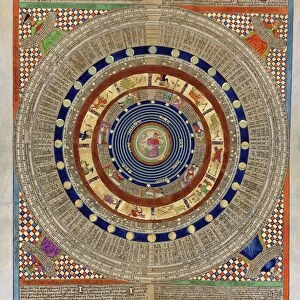
Catalan Atlas, Sheet 7, 1375 (pen and coloured inks on parchment)
")
![]()
Wall Art and Photo Gifts from Fine Art Finder
Catalan Atlas, Sheet 7, 1375 (pen and coloured inks on parchment)
5054643 Catalan Atlas, Sheet 7, 1375 (pen and coloured inks on parchment) by Cresques, Abraham (1325-87); Bibliotheque Nationale, Paris, France; (add.info.: World map made in Majorca, with Jerusalem close to the centre, attributed to the Jewish cartographer Abraham Cresques in the service of the king of Aragon. One of the few surviving examples of medieval cartography, richly illustrated and covers an area from the Atlantic to China, from Scandinavia to the Rio Oro in Africa in six parchment-covered wooden panels.); Spanish, out of copyright
Media ID 22322528
© Bridgeman Images
Atlas Cartography Catalan Catalan Atlas Catalonia Compass Compass Lines Cosmography Early Map Elephant Hydrography Majorcan Mappa Mundi Mediterranean Nautical Nautical Charts Navigation Navigational Portolan Sea Chart Sicily Silk Road Spice Trade Spices Vellum World Map
FEATURES IN THESE COLLECTIONS
> Africa
> Related Images
> Arts
> Artists
> C
> Abraham Cresques
> Asia
> China
> China Heritage Sites
> Silk Roads: the Routes Network of
> Europe
> France
> Paris
> Maps
> Europe
> Italy
> Sicily
> Related Images
> Fine Art Finder
> Artists
> Abraham Cresques
> Fine Art Finder
> Artists
> English School
EDITORS COMMENTS
This print showcases the Catalan Atlas, Sheet 7, a remarkable piece of medieval cartography created in 1375 by Abraham Cresques. Crafted with pen and colored inks on parchment, this world map offers a unique perspective on the known world during the 14th century. The Catalan Atlas is an exquisite example of navigational charts from that era, covering an extensive area from Scandinavia to China and from the Atlantic Ocean to Africa's Rio Oro. It is believed to have been made in Majorca under the patronage of the king of Aragon. What sets this map apart is its rich illustrations and attention to detail. Jerusalem holds a prominent position near the center, reflecting its significance as a spiritual hub during that time. The map also depicts various trade routes such as the Silk Road, highlighting Spain's involvement in global commerce and spice trade. Displayed across six parchment-covered wooden panels, this masterpiece provides insights into early maritime exploration and navigation techniques. Its intricate compass lines and coastal features demonstrate Cresques' mastery of hydrography. Preserved at Bibliotheque Nationale in Paris, France, this rare surviving artifact offers glimpses into medieval cosmography and serves as a testament to human curiosity about distant lands. Whether you're fascinated by history or captivated by ancient maps, this print transports you back in time to an era when cartographers were explorers themselves.
MADE IN AUSTRALIA
Safe Shipping with 30 Day Money Back Guarantee
FREE PERSONALISATION*
We are proud to offer a range of customisation features including Personalised Captions, Color Filters and Picture Zoom Tools
SECURE PAYMENTS
We happily accept a wide range of payment options so you can pay for the things you need in the way that is most convenient for you
* Options may vary by product and licensing agreement. Zoomed Pictures can be adjusted in the Cart.