Home > Arts > Artists > C > Abraham Cresques
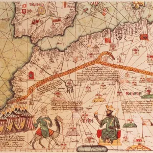
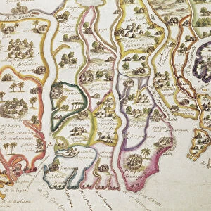
Detail from the Catalan Atlas, Sheet 6, showing the Western Sahara and Mansa Musa

![]()
Wall Art and Photo Gifts from Fine Art Finder
Detail from the Catalan Atlas, Sheet 6, showing the Western Sahara and Mansa Musa
5054637 Detail from the Catalan Atlas, Sheet 6, showing the Western Sahara and Mansa Musa, 1375 (pen with coloured inks on parchment) by Cresques, Abraham (1325-87); Bibliotheque Nationale, Paris, France; (add.info.: World map made in Majorca, with Jerusalem close to the centre, attributed to a Jewish cartographer in the service of the king of Aragon, covers an area from the Atlantic to China, from Scandinavia to the Rio Oro in Africa. The King of Mali, " Musse Melly" (Mansa Musa) holds a sceptre with a fleur-de-lys and a golden disc. He was known to control a large part of Africa, from Gambia and Senegal to Gao on the Niger, and had access to some of its richest gold deposits.); Spanish, out of copyright
Media ID 23258886
© Bridgeman Images
Atlas Atlas Mountains Camel Cartography Catalan Catalan Atlas Catalonia Compass Compass Lines Cosmography Early Map Hydrography Majorcan Mali Mansa Musa Mappa Mundi Mediterranean Nautical Nautical Charts Navigation Navigational Portolan River Niger Sea Chart Silk Road Spice Trade Spices Vellum World Map Western Sahara
FEATURES IN THESE COLLECTIONS
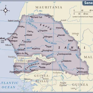
> Africa
> The Gambia
> Maps
> Africa
> Western Sahara
> Maps
> Animals
> Mammals
> Soricidae
> Niger
> Arts
> Artists
> C
> Abraham Cresques
> Arts
> Landscape paintings
> Waterfall and river artworks
> River artworks
> Asia
> China
> China Heritage Sites
> Silk Roads: the Routes Network of
> Fine Art Finder
> Artists
> Abraham Cresques
> Fine Art Finder
> Artists
> American Photographer (after)
EDITORS COMMENTS
This print showcases a stunning detail from the Catalan Atlas, Sheet 6, depicting the Western Sahara and Mansa Musa. Created in 1375 by Abraham Cresques, a Jewish cartographer in the service of the king of Aragon, this world map offers an expansive view from the Atlantic to China and Scandinavia to Africa's Rio Oro. At its center lies Jerusalem, surrounded by intricate nautical charts and compass lines that guided early explorers on their maritime journeys. The map also highlights significant geographical features such as the Atlas Mountains and the River Niger. Mansa Musa, known as "Musse Melly" is depicted holding a sceptre adorned with a fleur-de-lys and golden disc. As one of Africa's most influential rulers during his time, he controlled vast territories stretching from Gambia and Senegal to Gao on the Niger. Additionally, Mansa Musa had access to abundant gold deposits that contributed to his wealth. This remarkable artwork provides insights into medieval cartography while offering glimpses into historical trade routes like the Silk Road. Crafted meticulously on vellum using colored inks, it exemplifies both artistic skill and navigational precision. With its rich details capturing coastlines, shorelines, ports, and camel caravans traversing through North Africa's landscape; this piece invites viewers on an enchanting journey through time.
MADE IN AUSTRALIA
Safe Shipping with 30 Day Money Back Guarantee
FREE PERSONALISATION*
We are proud to offer a range of customisation features including Personalised Captions, Color Filters and Picture Zoom Tools
SECURE PAYMENTS
We happily accept a wide range of payment options so you can pay for the things you need in the way that is most convenient for you
* Options may vary by product and licensing agreement. Zoomed Pictures can be adjusted in the Cart.