Home > Animals > Insects > Hemiptera > Black Scale
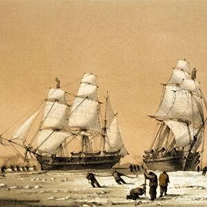
General chart of the Mediterranean Sea including the Gulf of Venice, Archipelago and part of the Black Sea with the steampacket routes, 1846 (coloured engraving)
")
![]()
Wall Art and Photo Gifts from Fine Art Finder
General chart of the Mediterranean Sea including the Gulf of Venice, Archipelago and part of the Black Sea with the steampacket routes, 1846 (coloured engraving)
7339360 General chart of the Mediterranean Sea including the Gulf of Venice, Archipelago and part of the Black Sea with the steampacket routes, 1846 (coloured engraving) by Wyld, James the Younger (1812-87); 57x98 cm; National Maritime Museum, London, UK; (add.info.: Creator: James Wyld; Wyld
Single sheet. Hand col. engr. Scale: [ca. 1:4 000 000]. Cartographic Note: Graduated. Contents Note: 8 different national packet ship routes marked. Outline colour shows political boundaries. Railways completed and under construction shown, View: Entrance of Gibraltar Bay.); © National Maritime Museum, Greenwich, London
Media ID 38176990
© © National Maritime Museum, Greenwich, London / Bridgeman Images
Archipelago Black Sea Cartography Mediterranean Sea Mediterrean Sea Venetians
FEATURES IN THESE COLLECTIONS
> Animals
> Insects
> Hemiptera
> Black Scale
> Arts
> Artists
> B
> James Bayes
> Europe
> Italy
> Veneto
> Related Images
> Europe
> Italy
> Veneto
> Venice
> Europe
> United Kingdom
> England
> London
> Boroughs
> Greenwich
> Europe
> United Kingdom
> England
> London
> Museums
> Greenwich Heritage Centre
> Europe
> United Kingdom
> England
> London
> Museums
> National Maritime Museum
> Fine Art Finder
> Artists
> Jacques Nicolas Bellin
> Fine Art Finder
> Artists
> James the Younger Wyld
EDITORS COMMENTS
This stunning colored engraving from 1846 by James Wyld the Younger showcases a General chart of the Mediterranean Sea, including the Gulf of Venice, Archipelago, and part of the Black Sea. The intricate details on this map provide a glimpse into maritime routes during the 19th century, with eight different national packet ship routes marked for reference.
The political boundaries are outlined in vibrant colors, giving insight into the various territories and regions that existed at that time. Additionally, railways completed and under construction are depicted on this historical map, offering a comprehensive view of transportation infrastructure in the region.
One notable feature is the view of the Entrance of Gibraltar Bay, adding an extra layer of depth to this already detailed cartographic masterpiece. The precision and artistry displayed in this engraving highlight Wyld's talent as a skilled cartographer.
Whether you're a history buff or simply appreciate fine art, this print from the National Maritime Museum in London is sure to captivate your imagination and transport you back to a bygone era when steam packets ruled the seas.
MADE IN AUSTRALIA
Safe Shipping with 30 Day Money Back Guarantee
FREE PERSONALISATION*
We are proud to offer a range of customisation features including Personalised Captions, Color Filters and Picture Zoom Tools
SECURE PAYMENTS
We happily accept a wide range of payment options so you can pay for the things you need in the way that is most convenient for you
* Options may vary by product and licensing agreement. Zoomed Pictures can be adjusted in the Cart.