Home > Africa > Comoros > Maps
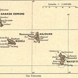
Map of Madagascar and Comoro Islands, c.1900 (engraving)
")
![]()
Wall Art and Photo Gifts from Fine Art Finder
Map of Madagascar and Comoro Islands, c.1900 (engraving)
533398 Map of Madagascar and Comoro Islands, c.1900 (engraving); (add.info.: Map of Madagascar and Comoro Islands, circa 1902, from the 10th edition of Encyclopaedia Britannica.); Encyclopaedia Britannica/UIG
Media ID 38208574
© Encyclopaedia Britannica/UIG / Bridgeman Images
1902 19th Century Style Archipelago Cartography Cut Out Guidance Illustration Technique Indian Ocean Madagascar Meridian Navigational Equipment Old Fashioned Physical Geography The Past Western Script White Background
FEATURES IN THESE COLLECTIONS
> Africa
> Comoros
> Related Images
> Africa
> Madagascar
> Maps
> Africa
> Madagascar
> Related Images
> Fine Art Finder
> Temp Classification
EDITORS COMMENTS
This stunning vintage engraving from the 10th edition of Encyclopaedia Britannica showcases a detailed Map of Madagascar and Comoro Islands, circa 1900. The intricate cartography captures the essence of exploration and discovery in the late 19th century, with its old-fashioned style and Western script labeling.
The map depicts the archipelago of Comoro Islands nestled in the Indian Ocean, surrounded by meridians and navigational equipment that hint at a time when sea travel was still a primary mode of transportation. The coastline of Madagascar is intricately outlined, showcasing the physical geography of this unique island.
As you gaze upon this historical print, you can't help but feel transported back in time to an era where maps were essential tools for understanding our world. The absence of people on the map only adds to its mystique, allowing us to focus solely on the rich history and significance it holds.
Whether you're a lover of history or simply appreciate fine illustration techniques, this Map of Madagascar and Comoro Islands is sure to captivate your imagination and inspire thoughts of adventure and exploration. Let it serve as a reminder that even in today's modern world, there is still so much left to discover about our planet's past.
MADE IN AUSTRALIA
Safe Shipping with 30 Day Money Back Guarantee
FREE PERSONALISATION*
We are proud to offer a range of customisation features including Personalised Captions, Color Filters and Picture Zoom Tools
SECURE PAYMENTS
We happily accept a wide range of payment options so you can pay for the things you need in the way that is most convenient for you
* Options may vary by product and licensing agreement. Zoomed Pictures can be adjusted in the Cart.