Fine Art Print > Fine Art Storehouse > Map
Fine Art Print : antiquity, archival, atlantic ocean, cartography, colonialism, continent, geographical


![]()
Fine Art Prints from Fine Art Storehouse
antiquity, archival, atlantic ocean, cartography, colonialism, continent, geographical
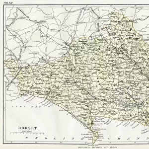
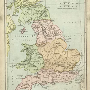
antiquity, archival, atlantic ocean, cartography, colonialism, continent, geographical, geography, historic, latitude, longitude, map, new world, nobody, old-fashioned, pacific ocean, south america, text, vintage, Antique Maps, 87716724
Unleash your creativity and transform your space into a visual masterpiece!
Hemera Technologies
Media ID 14761266
© Getty Images
Antiquity Atlantic Ocean Colonialism Continent Geographical Geography Latitude Longitude New World Pacific Ocean South America Text
20"x16" (+3" Border) Fine Art Print
Step back in time with our exquisite selection of Fine Art Prints from Media Storehouse. This captivating image, titled 'Atlantic and Pacific Oceans: A Geographical Exploration of the Old World and the New,' transports you to an era of antiquity and colonialism. The intricate cartography showcases the continents of Europe, Africa, and the Americas, marked by their latitude and longitude lines. The vast Atlantic and Pacific Oceans stretch out in all their historic grandeur, with the mysterious New World waiting to be discovered. With archival quality printing, these old-fashioned maps are not just works of art, but also a testament to the human spirit of exploration and the wonders of geography. Bring a piece of history into your home or office with this stunning Fine Art Print.
20x16 image printed on 26x22 Fine Art Rag Paper with 3" (76mm) white border. Our Fine Art Prints are printed on 300gsm 100% acid free, PH neutral paper with archival properties. This printing method is used by museums and art collections to exhibit photographs and art reproductions.
Our fine art prints are high-quality prints made using a paper called Photo Rag. This 100% cotton rag fibre paper is known for its exceptional image sharpness, rich colors, and high level of detail, making it a popular choice for professional photographers and artists. Photo rag paper is our clear recommendation for a fine art paper print. If you can afford to spend more on a higher quality paper, then Photo Rag is our clear recommendation for a fine art paper print.
Estimated Image Size (if not cropped) is 48.8cm x 40.6cm (19.2" x 16")
Estimated Product Size is 66cm x 55.9cm (26" x 22")
These are individually made so all sizes are approximate
Artwork printed orientated as per the preview above, with landscape (horizontal) orientation to match the source image.
FEATURES IN THESE COLLECTIONS
> Fine Art Storehouse
> Map
> Historical Maps
EDITORS COMMENTS
This print by Hemera Technologies takes us on a journey through time and space, capturing the essence of antiquity and colonialism. The image showcases an exquisite antique map, meticulously crafted with archival precision. Its faded colors and old-fashioned charm transport us to an era when cartography was both a science and an art. The map itself is a testament to the exploration and conquests that shaped our world. It spans across continents, depicting the vastness of the Atlantic Ocean as well as the Pacific Ocean. South America emerges prominently, reminding us of its pivotal role in history's narrative. As we delve into this vintage piece, we are reminded of the significance of latitude and longitude in navigating uncharted territories. Each line represents countless adventures undertaken by brave explorers who sought to uncover new lands in what was then known as the New World. The text accompanying this remarkable map remains hidden from view, leaving room for imagination to fill in historical details that have been lost over time. This evocative composition invites us to reflect on how geography has shaped our understanding of cultures past and present. In this photo print, Fine Art Storehouse offers more than just a visual feast; it provides a gateway into centuries-old narratives waiting to be discovered anew.
MADE IN AUSTRALIA
Safe Shipping with 30 Day Money Back Guarantee
FREE PERSONALISATION*
We are proud to offer a range of customisation features including Personalised Captions, Color Filters and Picture Zoom Tools
SECURE PAYMENTS
We happily accept a wide range of payment options so you can pay for the things you need in the way that is most convenient for you
* Options may vary by product and licensing agreement. Zoomed Pictures can be adjusted in the Cart.