Metal Print > Fine Art Storehouse > Map
Metal Print : antiquity, archival, atlantic ocean, cartography, colonialism, continent, geographical


![]()
Metal Prints from Fine Art Storehouse
antiquity, archival, atlantic ocean, cartography, colonialism, continent, geographical
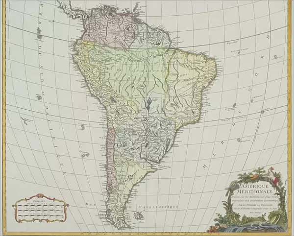
antiquity, archival, atlantic ocean, cartography, colonialism, continent, geographical, geography, historic, latitude, longitude, map, new world, nobody, old-fashioned, pacific ocean, south america, text, vintage, Antique Maps, 87716724
Unleash your creativity and transform your space into a visual masterpiece!
Hemera Technologies
Media ID 14761266
© Getty Images
Antiquity Atlantic Ocean Colonialism Continent Geographical Geography Latitude Longitude New World Pacific Ocean South America Text
10"x8" (25x20cm) Table Top Metal Print
Step back in time with Media Storehouse's Metal Prints featuring historic cartography from Fine Art Storehouse. These captivating pieces showcase the ancient world with intricate maps of continents, including South America and the Atlantic and Pacific Oceans. Delve into the rich history of cartography and colonialism with detailed depictions of latitude and longitude lines, old-fashioned maps, and geographical features. Each print is made with archival quality materials for lasting beauty and preservation. Bring a piece of the past into your home or office and add an air of sophistication and historic charm.
Table Top Metal Prints feature rounded corners and an easel back for easy display. Available in two sizes, 18x13cm (7x5) or 25x20cm (10x8). Lightweight and vibrant, they are perfect for displaying artwork and are guaranteed to add style to any desk or table top. The unique material is fade, moisture, chemical and scratch resistant to help ensure this art lasts a lifetime.
Made with durable metal and luxurious printing techniques, metal prints bring images to life and add a modern touch to any space
Estimated Product Size is 25.4cm x 20.3cm (10" x 8")
These are individually made so all sizes are approximate
Artwork printed orientated as per the preview above, with landscape (horizontal) or portrait (vertical) orientation to match the source image.
FEATURES IN THESE COLLECTIONS
> Fine Art Storehouse
> Map
> Historical Maps
EDITORS COMMENTS
This print by Hemera Technologies takes us on a journey through time and space, capturing the essence of antiquity and colonialism. The image showcases an exquisite antique map, meticulously crafted with archival precision. Its faded colors and old-fashioned charm transport us to an era when cartography was both a science and an art. The map itself is a testament to the exploration and conquests that shaped our world. It spans across continents, depicting the vastness of the Atlantic Ocean as well as the Pacific Ocean. South America emerges prominently, reminding us of its pivotal role in history's narrative. As we delve into this vintage piece, we are reminded of the significance of latitude and longitude in navigating uncharted territories. Each line represents countless adventures undertaken by brave explorers who sought to uncover new lands in what was then known as the New World. The text accompanying this remarkable map remains hidden from view, leaving room for imagination to fill in historical details that have been lost over time. This evocative composition invites us to reflect on how geography has shaped our understanding of cultures past and present. In this photo print, Fine Art Storehouse offers more than just a visual feast; it provides a gateway into centuries-old narratives waiting to be discovered anew.
MADE IN AUSTRALIA
Safe Shipping with 30 Day Money Back Guarantee
FREE PERSONALISATION*
We are proud to offer a range of customisation features including Personalised Captions, Color Filters and Picture Zoom Tools
SECURE PAYMENTS
We happily accept a wide range of payment options so you can pay for the things you need in the way that is most convenient for you
* Options may vary by product and licensing agreement. Zoomed Pictures can be adjusted in the Cart.