Fine Art Print > Europe > France > Canton > Landes
Fine Art Print : map of the world 1855


![]()
Fine Art Prints from Fine Art Storehouse
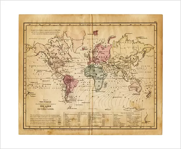
map of the world 1855
map of the world illustrating the principal features of the land and the co-tidal lines - 1855
Unleash your creativity and transform your space into a visual masterpiece!
THEPALMER
Media ID 21177689
© Roberto A Sanchez
Atlas Australia Backgrounds Earth Grunge Map03 North America Oceania Pacific Ocean Paper Patina Retro Revival South America Stained Textured Effect The Americas World Map
20"x16" (+3" Border) Fine Art Print
Discover the captivating allure of yesteryears with our exquisite Fine Art Print of the World Map by THEPALMER, dating back to 1855. This intricately detailed representation of the globe showcases the principal landmasses and co-tidal lines, offering a glimpse into the geographical knowledge of a bygone era. Bring history into your home or office and add an air of sophistication with this stunning piece of cartographic artistry.
20x16 image printed on 26x22 Fine Art Rag Paper with 3" (76mm) white border. Our Fine Art Prints are printed on 300gsm 100% acid free, PH neutral paper with archival properties. This printing method is used by museums and art collections to exhibit photographs and art reproductions.
Our fine art prints are high-quality prints made using a paper called Photo Rag. This 100% cotton rag fibre paper is known for its exceptional image sharpness, rich colors, and high level of detail, making it a popular choice for professional photographers and artists. Photo rag paper is our clear recommendation for a fine art paper print. If you can afford to spend more on a higher quality paper, then Photo Rag is our clear recommendation for a fine art paper print.
Estimated Image Size (if not cropped) is 48cm x 40.6cm (18.9" x 16")
Estimated Product Size is 66cm x 55.9cm (26" x 22")
These are individually made so all sizes are approximate
Artwork printed orientated as per the preview above, with landscape (horizontal) orientation to match the source image.
FEATURES IN THESE COLLECTIONS
> Africa
> Related Images
> Africa
> South Africa
> Maps
> Africa
> South Africa
> Related Images
> Arts
> Artists
> O
> Oceanic Oceanic
> Europe
> France
> Canton
> Landes
> Maps and Charts
> Related Images
> Maps and Charts
> World
> Fine Art Storehouse
> Map
> Historical Maps
EDITORS COMMENTS
This print titled "Map of the World 1855" takes us on a journey back in time to explore the intricate details and beauty of cartography from the past. The image showcases an antique map, illustrating the principal features of land and co-tidal lines as they were understood in 1855. The retro revival aesthetic adds a touch of nostalgia, transporting us to an era when travel was more adventurous and mysterious. The stained texture and old-fashioned paper evoke a sense of history, reminding us of the countless explorers who once relied on maps like these to navigate uncharted territories. The map itself is a testament to physical geography, showcasing continents such as Europe, Africa, North America, South America, Australia, and Oceania. It also highlights the vastness of our planet's oceans with particular emphasis on the Pacific Ocean. With its grunge effect and patina overlay, this print exudes character and charm. It serves as both a decorative piece for any space and an educational tool that sparks curiosity about our world's ever-changing landscapes. "The Map of the World 1855" by THEPALMER captures not only geographical accuracy but also encapsulates the spirit of exploration that has driven humanity throughout history. Whether you are a lover of vintage aesthetics or simply fascinated by our planet's diverse topography, this artwork invites you to embark on your own voyage through time.
MADE IN AUSTRALIA
Safe Shipping with 30 Day Money Back Guarantee
FREE PERSONALISATION*
We are proud to offer a range of customisation features including Personalised Captions, Color Filters and Picture Zoom Tools
SECURE PAYMENTS
We happily accept a wide range of payment options so you can pay for the things you need in the way that is most convenient for you
* Options may vary by product and licensing agreement. Zoomed Pictures can be adjusted in the Cart.